IMAGES TAKEN NEAR TO
North Drive, SLEAFORD, NG34 8HU
Introduction
This page details the photographs taken nearby to North Drive, NG34 8HU by members of the Geograph project.
The Geograph project started in 2005 with the aim of publishing, organising and preserving representative images for every square kilometre of Great Britain, Ireland and the Isle of Man.

There are currently over 7.5m images from over14,400 individuals and you can help contribute to the project by visiting https://www.geograph.org.uk
Image Map
Images are licensed for reuse under creativecommons.org/licenses/by-sa/2.0
Notes
- Clicking on the map will re-center to the selected point.
- The higher the marker number, the further away the image location is from the centre of the postcode.
Image Listing (7 Images Found)
Images are licensed for reuse under creativecommons.org/licenses/by-sa/2.0
Image
Details
Distance


3
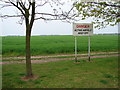
Airfield to North of Main RAF Cranwell Air Base
Generally used for Gliders now. Once used as base for Sea Scout Airships.
Image: © Ian Paterson
Taken: 21 Apr 2007
0.13 miles
4
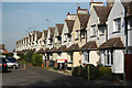
Delhi Square
Houses in Delhi Square at RAF Cranwell
Image: © Richard Croft
Taken: 24 Oct 2011
0.18 miles


