IMAGES TAKEN NEAR TO
Edmunds Road, SLEAFORD, NG34 8EP
Introduction
This page details the photographs taken nearby to Edmunds Road, NG34 8EP by members of the Geograph project.
The Geograph project started in 2005 with the aim of publishing, organising and preserving representative images for every square kilometre of Great Britain, Ireland and the Isle of Man.

There are currently over 7.5m images from over14,400 individuals and you can help contribute to the project by visiting https://www.geograph.org.uk
Image Map
Images are licensed for reuse under creativecommons.org/licenses/by-sa/2.0
Notes
- Clicking on the map will re-center to the selected point.
- The higher the marker number, the further away the image location is from the centre of the postcode.
Image Listing (43 Images Found)
Images are licensed for reuse under creativecommons.org/licenses/by-sa/2.0
Image
Details
Distance
1
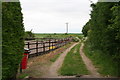
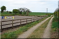
Track to the sewage works
Off De Gravel Drive, next to a riding area (manege), there is not a public footpath marked on the map at this point but the dog-poo bin suggests it is used as such.
Image: © Chris
Taken: 8 Jun 2013
0.06 miles

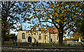
3

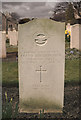
Cross of Sacrifice at Cranwell
Cranwell churchyard contains 73 War Graves and numerous other RAF graves most of which can be seen in the picture.
Image: © Adrian S Pye
Taken: 7 Jun 2017
0.11 miles
4
An Airman's Last Resting Place - Cranwell
Far from where he met his fate, among many such as he, lies the grave of Flt. Lt. Frank Whitehouse RAF. On the date shown he took off in a Lightning interceptor at RAF Tengah in Singapore and in attempting one of the Lightning's spectacular rotation take offs the aircraft over rotated causing it to become unstable whereupon it crashed to earth costing him his young life. Respected by his aircrew colleagues and those of us who served in lesser roles on 74 Sqn. he was to be sadly missed. Tiger! Tiger!
Image: © Mick Lobb
Taken: 26 Mar 2014
0.12 miles
5
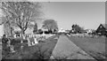
Military Graves, St Andrew's church, Cranwell
Mostly for RAF servicemen who died in the war.
Image: © Julian P Guffogg
Taken: 19 Apr 2018
0.12 miles
6
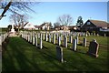
Fallen airmen
Some of the RAF graves in St.Andrew's churchyard
Image: © Richard Croft
Taken: 3 Feb 2008
0.12 miles
7
Public Footpath off De Gravel Drive, Cranwell Village
The land to the west is a horse-jumping area.
Image: © Ian Paterson
Taken: 20 Apr 2007
0.12 miles

10
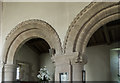
Norman arcade, St Andrew's church, Cranwell
The north arcade of the church.
Image: © Julian P Guffogg
Taken: 19 Apr 2018
0.12 miles