IMAGES TAKEN NEAR TO
College Road, SLEAFORD, NG34 8DU
Introduction
This page details the photographs taken nearby to College Road, NG34 8DU by members of the Geograph project.
The Geograph project started in 2005 with the aim of publishing, organising and preserving representative images for every square kilometre of Great Britain, Ireland and the Isle of Man.

There are currently over 7.5m images from over14,400 individuals and you can help contribute to the project by visiting https://www.geograph.org.uk
Image Map
Images are licensed for reuse under creativecommons.org/licenses/by-sa/2.0
Notes
- Clicking on the map will re-center to the selected point.
- The higher the marker number, the further away the image location is from the centre of the postcode.
Image Listing (14 Images Found)
Images are licensed for reuse under creativecommons.org/licenses/by-sa/2.0
Image
Details
Distance

2
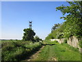
Green Lane, Cranwell
A bridleway to Brauncewell.
Image: © Jonathan Thacker
Taken: 14 May 2019
0.02 miles
4
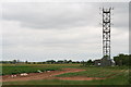
Tower by the runway
One of two towers, probably connected with the landing system at R.A.F. Cranwell.
To the left is an irrigation system.
Image: © Chris
Taken: 8 Jun 2013
0.10 miles

6
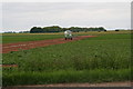
A dry spring and summer: irrigation system west of Cranwell village
Image: © Chris
Taken: 8 Jun 2013
0.13 miles
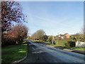
8
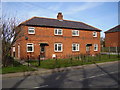
34-36 College Road Cranwell
Houses, most likely built as part of RAF Cranwell. These two relatively unaltered.
Image: © Ken Brockway
Taken: 10 Mar 2007
0.18 miles
10
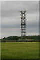
Tower by the runway
One of two towers, probably connected with the landing system at R.A.F. Cranwell.
Image: © Chris
Taken: 8 Jun 2013
0.19 miles