IMAGES TAKEN NEAR TO
Tower View, SLEAFORD, NG34 7TE
Introduction
This page details the photographs taken nearby to Tower View, NG34 7TE by members of the Geograph project.
The Geograph project started in 2005 with the aim of publishing, organising and preserving representative images for every square kilometre of Great Britain, Ireland and the Isle of Man.

There are currently over 7.5m images from over14,400 individuals and you can help contribute to the project by visiting https://www.geograph.org.uk
Image Map
Images are licensed for reuse under creativecommons.org/licenses/by-sa/2.0
Notes
- Clicking on the map will re-center to the selected point.
- The higher the marker number, the further away the image location is from the centre of the postcode.
Image Listing (19 Images Found)
Images are licensed for reuse under creativecommons.org/licenses/by-sa/2.0
Image
Details
Distance
1
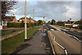
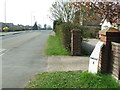
Grantham Road
Grantham Road at Quarrington on the outskirts of Sleaford
Image: © Richard Croft
Taken: 11 Nov 2010
0.08 miles
2
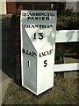
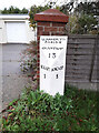
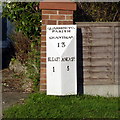
Old Milestone, on the B1517, Quarrington
By No. 236 Grantham Road, located on the North side of road, on the verge. Cast iron post, Hornsby iron casting design, erected by an unknown authority, 19th century. Alternative views see http://www.geograph.org.uk/photo/6675759 & http://www.geograph.org.uk/photo/2869422 & http://www.geograph.org.uk/photo/2155790 & http://www.geograph.org.uk/photo/2869410
Inscription reads: // SLEAFᴰ. / 1 //ANCASᴿ. / 5 //QUARRINGTON / PARISH / GRANTHAM / 13
Milestone Society National ID: LI_SLAN01 Alternative views see http://www.geograph.org.uk/photo/6675759 & http://www.geograph.org.uk/photo/2869422 & http://www.geograph.org.uk/photo/2155790 & http://www.geograph.org.uk/photo/2869410
Image: © Milestone Society
Taken: Unknown
0.08 miles
3
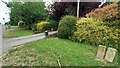
Grantham Road, looking towards the town
There is an old cast-iron milepost http://www.geograph.org.uk/photo/4291182 on the left.
Image: © Alan Murray-Rust
Taken: 24 Dec 2014
0.08 miles
4
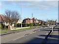
View eastwards along B1517
There is a milepost Image against a brick wall pier on the left hand side of the road
Image: © Roger Templeman
Taken: 27 Jun 2023
0.08 miles
5
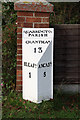
Milestone, Grantham Rd, Sleaford
On the North Eastern side of the road.
Quarrintoₙ / Parish / Grantham 13 / Sleafᴰ 1 / Ancasᴿ 5
Milestone Society National ID: LI_SLAN01
Image: © Graham Munday
Taken: 14 Nov 2020
0.09 miles
6
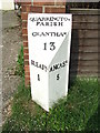
Quarrington milepost
Milepost on Grantham Road http://www.geograph.org.uk/photo/2155783
Sleaford 1
Ancaster 5
Image: © Richard Croft
Taken: 11 Nov 2010
0.09 miles
7
Old Milepost
Old milepost at Sleaford, Lincolnshire. For overall view see http://www.geograph.org.uk/photo/2869422
Image: © Keith Evans
Taken: 24 Mar 2012
0.09 miles
8
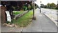
Entrance drives to Nos. 218a and 218 (Sheohar House) on north side of Grantham Road
Ordnance Survey documents indicate that cut mark benchmark levelled in 1955 at 28.613m above Newlyn Datum was verified in 1970 on a culvert at the entrance to No. 218.
Image: © Roger Templeman
Taken: 27 Jun 2023
0.09 miles
9
Milepost
Old milepost at Sleaford, Lincolnshire. For close up view see http://www.geograph.org.uk/photo/2869410
Image: © Keith Evans
Taken: 24 Mar 2012
0.10 miles
10
Milepost on Grantham Road
A well looked after cast iron example.
Image: © Alan Murray-Rust
Taken: 24 Dec 2014
0.11 miles