IMAGES TAKEN NEAR TO
Electric Station Road, SLEAFORD, NG34 7QJ
Introduction
This page details the photographs taken nearby to Electric Station Road, NG34 7QJ by members of the Geograph project.
The Geograph project started in 2005 with the aim of publishing, organising and preserving representative images for every square kilometre of Great Britain, Ireland and the Isle of Man.

There are currently over 7.5m images from over14,400 individuals and you can help contribute to the project by visiting https://www.geograph.org.uk
Image Map
Images are licensed for reuse under creativecommons.org/licenses/by-sa/2.0
Notes
- Clicking on the map will re-center to the selected point.
- The higher the marker number, the further away the image location is from the centre of the postcode.
Image Listing (44 Images Found)
Images are licensed for reuse under creativecommons.org/licenses/by-sa/2.0
Image
Details
Distance
1
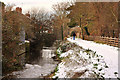
Rauceby Banks on the River Slea - Sleaford
Image: © Mick Lobb
Taken: 23 Dec 2009
0.04 miles
2
Rauceby Banks on the River Slea - Sleaford
Image: © Mick Lobb
Taken: 23 Dec 2009
0.07 miles
3
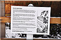
Rauceby Banks information sign - Sleaford
Image: © Mick Lobb
Taken: 23 Dec 2009
0.08 miles
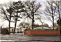


8
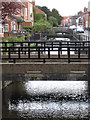
Sleaford - bridges over River Slea at West Banks
For an alternative view, please see Image
Image: © Dave Bevis
Taken: 10 Apr 2012
0.14 miles
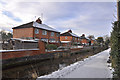
9
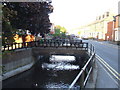
River Slea at Sleaford
The River Slea running alongside West Banks in Sleaford.
Image: © Malc McDonald
Taken: 11 Sep 2010
0.14 miles
10

The River Slea - Sleaford
It is at this point that the Slea first enters the populated area of the town after leaving fields lying to the west.
Image: © Mick Lobb
Taken: 23 Dec 2009
0.15 miles