IMAGES TAKEN NEAR TO
Copeland Court, SLEAFORD, NG34 7PL
Introduction
This page details the photographs taken nearby to Copeland Court, NG34 7PL by members of the Geograph project.
The Geograph project started in 2005 with the aim of publishing, organising and preserving representative images for every square kilometre of Great Britain, Ireland and the Isle of Man.

There are currently over 7.5m images from over14,400 individuals and you can help contribute to the project by visiting https://www.geograph.org.uk
Image Map
Images are licensed for reuse under creativecommons.org/licenses/by-sa/2.0
Notes
- Clicking on the map will re-center to the selected point.
- The higher the marker number, the further away the image location is from the centre of the postcode.
Image Listing (24 Images Found)
Images are licensed for reuse under creativecommons.org/licenses/by-sa/2.0
Image
Details
Distance
1
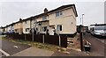
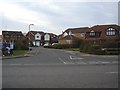
Houses on Grantham Road at junction with Charlotte Street
There is an Ordnance Survey benchmark Image on the side of the right hand house at its front corner
Image: © Roger Templeman
Taken: 27 Jun 2023
0.07 miles
2

Benchmark on side of #144 Grantham Road
Ordnance Survey cut mark benchmark levelled in 1955 at 24.420m above Newlyn Datum verified 1969
Image: © Roger Templeman
Taken: 27 Jun 2023
0.08 miles
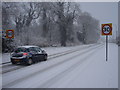
3
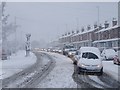
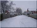
Happy motoring!
Sleaford commuter traffic queueing along Grantham Road on an unusually snowy morning.
Image: © Ian Paterson
Taken: 18 Dec 2009
0.12 miles
4
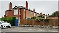
Nos. 73 and 71 Grantham Road viewed from St Edmunds Road
There is an Ordnance Survey benchmark Image on the right hand side of the jut on the left hand face of the nearer house (behind the blue gate)
Image: © Roger Templeman
Taken: 27 Jun 2023
0.17 miles
5
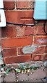
Benchmark on jut on St Edmunds Road face of #73 Grantham Road
Ordnance Survey cut mark benchmark levelled at 22.250m above Newlyn Datum verified 1966
Image: © Roger Templeman
Taken: 27 Jun 2023
0.17 miles
6
Footpath in the snow
Looking in an easterly direction along the public footpath which skirts around the housing estate.
Image: © Ian Paterson
Taken: 18 Dec 2009
0.18 miles
8
Close up of Dryad in London Road
See Image for more information and a long shot.
Image: © Ian Paterson
Taken: 15 Apr 2006
0.19 miles
9
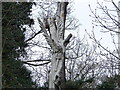
Dryad in Goodson's / Godson's Holt by Jason Thompson
Sadly no longer with us, this sculpture was created c.1996 on a dying tree, which sprouted branches one last time before dying along with the tree nymph depicted. See a close up here Image
This was one of a number of installations initiated by the local Council's New Life Scheme.
The site is managed by the Woodland Trust https://www.woodlandtrust.org.uk/visiting-woods/woods/godsons-holt/.
Image: © Ian Paterson
Taken: 15 Apr 2006
0.19 miles
10
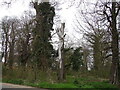
Let it snow, let it snow, let it snow!
Snow. One answer to the speeding problem!
View along London Road near the wooded area known as Goodson's Holt to the left of the shot.
Image: © Ian Paterson
Taken: 18 Dec 2009
0.20 miles