IMAGES TAKEN NEAR TO
Wesley Close, SLEAFORD, NG34 7LX
Introduction
This page details the photographs taken nearby to Wesley Close, NG34 7LX by members of the Geograph project.
The Geograph project started in 2005 with the aim of publishing, organising and preserving representative images for every square kilometre of Great Britain, Ireland and the Isle of Man.

There are currently over 7.5m images from over14,400 individuals and you can help contribute to the project by visiting https://www.geograph.org.uk
Image Map
Images are licensed for reuse under creativecommons.org/licenses/by-sa/2.0
Notes
- Clicking on the map will re-center to the selected point.
- The higher the marker number, the further away the image location is from the centre of the postcode.
Image Listing (31 Images Found)
Images are licensed for reuse under creativecommons.org/licenses/by-sa/2.0
Image
Details
Distance
1
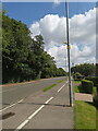
Speeders beware!
The ongoing speeding problem here (Image, Image, Image, https://www.lincolnshirelive.co.uk/news/local-news/30mph-lincolnshire-road-drivers-still-6414994 ) was temporarily resolved after one fine upstanding member of the community erected an authentic looking 'speed camera', sadly only to have been made to remove it by those who claim to know better.
For a short while at least, the traffic noise and average speed was significantly reduced.
After its removal, traffic was back to its normal "I don't care if I kill a child" speed. Why can't the Council see when someone is doing everyone a favour, free of charge?
It even made the BBC news : https://www.bbc.co.uk/news/articles/c72v1prdm88o
Image: © Ian Paterson
Taken: 17 Jul 2024
0.08 miles
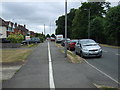
2
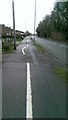
Quality control, Sleaford style
The perfectly straight line separating the pedestrian from the cyclist takes a turn for the worst at this point. I guess the line-maker had an extra-large hiccup when it was being set out but recovered well shortly afterwards!
Image: © Ian Paterson
Taken: 19 Dec 2019
0.08 miles
3
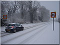
Let it snow, let it snow, let it snow!
Snow. One answer to the speeding problem!
View along London Road near the wooded area known as Goodson's Holt to the left of the shot.
Image: © Ian Paterson
Taken: 18 Dec 2009
0.08 miles
4
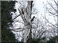
Close up of Dryad in London Road
See Image for more information and a long shot.
Image: © Ian Paterson
Taken: 15 Apr 2006
0.09 miles
5
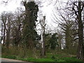
Dryad in Goodson's / Godson's Holt by Jason Thompson
Sadly no longer with us, this sculpture was created c.1996 on a dying tree, which sprouted branches one last time before dying along with the tree nymph depicted. See a close up here Image
This was one of a number of installations initiated by the local Council's New Life Scheme.
The site is managed by the Woodland Trust https://www.woodlandtrust.org.uk/visiting-woods/woods/godsons-holt/.
Image: © Ian Paterson
Taken: 15 Apr 2006
0.09 miles
7
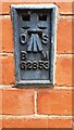
Benchmark on #104 London Road
Ordnance Survey flush bracket (serial identifier G2853) benchmark levelled in 1954 at 21.622m above Newlyn Datum verified 1970
Image: © Roger Templeman
Taken: 27 Jun 2023
0.10 miles
8
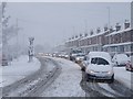
Happy motoring!
Sleaford commuter traffic queueing along Grantham Road on an unusually snowy morning.
Image: © Ian Paterson
Taken: 18 Dec 2009
0.10 miles
10
#104 London Road behind garden trees
There is an Ordnance Survey benchmark Image on the left hand side of the house at its near corner beside the black downpipe
Image: © Roger Templeman
Taken: 27 Jun 2023
0.11 miles