IMAGES TAKEN NEAR TO
Old Place, SLEAFORD, NG34 7HR
Introduction
This page details the photographs taken nearby to Old Place, NG34 7HR by members of the Geograph project.
The Geograph project started in 2005 with the aim of publishing, organising and preserving representative images for every square kilometre of Great Britain, Ireland and the Isle of Man.

There are currently over 7.5m images from over14,400 individuals and you can help contribute to the project by visiting https://www.geograph.org.uk
Image Map
Images are licensed for reuse under creativecommons.org/licenses/by-sa/2.0
Notes
- Clicking on the map will re-center to the selected point.
- The higher the marker number, the further away the image location is from the centre of the postcode.
Image Listing (103 Images Found)
Images are licensed for reuse under creativecommons.org/licenses/by-sa/2.0
Image
Details
Distance
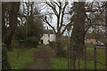
3
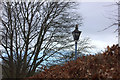
Footpath southwards from Boston Road
Leading along the edge of the recreation ground.
Image: © Robert Eva
Taken: 15 Jan 2020
0.09 miles
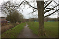
4
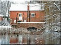
Path from Boston Road to River Slea
At the Boston Road end. The police station is on the right.
Image: © Robert Eva
Taken: 15 Jan 2020
0.12 miles
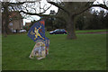
5
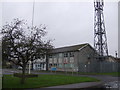
Police station sign on Boston Road
There is a large modern police station on the other side of the hedge.
Image: © Robert Eva
Taken: 15 Jan 2020
0.14 miles
6
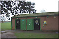
Boston Road recreation ground toilet block
High tech and high security, judging by those doors.
Image: © Robert Eva
Taken: 15 Jan 2020
0.15 miles
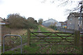
10
Gate on path to River Slea
Looking northwards from Boston road end of the path.
Image: © Robert Eva
Taken: 15 Jan 2020
0.17 miles