IMAGES TAKEN NEAR TO
Milton Way, SLEAFORD, NG34 7GE
Introduction
This page details the photographs taken nearby to Milton Way, NG34 7GE by members of the Geograph project.
The Geograph project started in 2005 with the aim of publishing, organising and preserving representative images for every square kilometre of Great Britain, Ireland and the Isle of Man.

There are currently over 7.5m images from over14,400 individuals and you can help contribute to the project by visiting https://www.geograph.org.uk
Image Map (Loading...)


Getting Data...Please wait
Leaflet Map data © OpenStreetMap
Images are licensed for reuse under creativecommons.org/licenses/by-sa/2.0
Notes
- Clicking on the map will re-center to the selected point.
- The higher the marker number, the further away the image location is from the centre of the postcode.
Image Listing (11 Images Found)
Images are licensed for reuse under creativecommons.org/licenses/by-sa/2.0
Image
Details
Distance
1
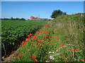
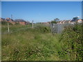
Pretty flowers
Great display of wildflowers alongside the footpath, here looking towards the Bass Maltings.
Image: © Ian Paterson
Taken: 3 Jul 2019
0.18 miles
2
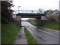
Railway bridge over Boston Road
Looking east.
Image: © JThomas
Taken: 18 Oct 2014
0.20 miles
3
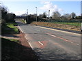
Bridge on the Edge
This railway bridge is so close to the western edge of this square that the road through the other side is in the next square west. The railway leads north to Lincoln.
Image: © Michael Patterson
Taken: 9 Mar 2007
0.20 miles
4
Railway bridge over Boston Road
Looking west.
Image: © JThomas
Taken: 18 Oct 2014
0.20 miles
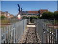
5
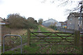
Pedestrian traffic only
Such a narrow gate to pass through to get over the railway line. Clearly measures have been put in place to prevent cyclists crossing here too.
Image: © Ian Paterson
Taken: 3 Jul 2019
0.20 miles
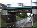
6
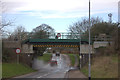
Boston Road bridge
This bridge carries the Sleaford avoiding railway line over Boston Road. It is prone to flooding, as seen here.
Image: © Robert Eva
Taken: 15 Jan 2020
0.20 miles
7
Neat crossing
Well maintained public footpath crossing the railway line. Shame about the state of the path after this point. Nettles - ouch!
Image: © Ian Paterson
Taken: 3 Jul 2019
0.20 miles
8
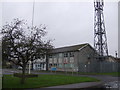
Police station sign on Boston Road
There is a large modern police station on the other side of the hedge.
Image: © Robert Eva
Taken: 15 Jan 2020
0.21 miles
10
Path from Boston Road to River Slea
At the Boston Road end. The police station is on the right.
Image: © Robert Eva
Taken: 15 Jan 2020
0.22 miles