IMAGES TAKEN NEAR TO
Rookery Avenue, SLEAFORD, NG34 7FE
Introduction
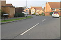
This page details the photographs taken nearby to Rookery Avenue, NG34 7FE by members of the Geograph project.
The Geograph project started in 2005 with the aim of publishing, organising and preserving representative images for every square kilometre of Great Britain, Ireland and the Isle of Man.

There are currently over 7.5m images from over14,400 individuals and you can help contribute to the project by visiting https://www.geograph.org.uk
Image Map
Images are licensed for reuse under creativecommons.org/licenses/by-sa/2.0
Notes
- Clicking on the map will re-center to the selected point.
- The higher the marker number, the further away the image location is from the centre of the postcode.
Image Listing (5 Images Found)
Images are licensed for reuse under creativecommons.org/licenses/by-sa/2.0
Image
Details
Distance
2
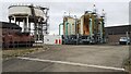
Clayhill Water Treatment Works and Sleaford Water Tower
Image: © Roger Templeman
Taken: 27 Jun 2023
0.09 miles
3
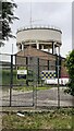
Sleaford Water Tower
The centre of the water tower is a component of an Ordnance Survey intersected station trig point, https://trigpointing.uk/trig/13478. Ordnance Survey records also indicate that a cut mark benchmark levelled at 30.425m above Newlyn Datum was verified on the west face an abutment of the tower which is within a secure compound
Image: © Roger Templeman
Taken: 27 Jun 2023
0.09 miles

5
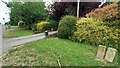
Entrance drives to Nos. 218a and 218 (Sheohar House) on north side of Grantham Road
Ordnance Survey documents indicate that cut mark benchmark levelled in 1955 at 28.613m above Newlyn Datum was verified in 1970 on a culvert at the entrance to No. 218.
Image: © Roger Templeman
Taken: 27 Jun 2023
0.24 miles