IMAGES TAKEN NEAR TO
Albion Terrace, SLEAFORD, NG34 7EY
Introduction
This page details the photographs taken nearby to Albion Terrace, NG34 7EY by members of the Geograph project.
The Geograph project started in 2005 with the aim of publishing, organising and preserving representative images for every square kilometre of Great Britain, Ireland and the Isle of Man.

There are currently over 7.5m images from over14,400 individuals and you can help contribute to the project by visiting https://www.geograph.org.uk
Image Map
Images are licensed for reuse under creativecommons.org/licenses/by-sa/2.0
Notes
- Clicking on the map will re-center to the selected point.
- The higher the marker number, the further away the image location is from the centre of the postcode.
Image Listing (338 Images Found)
Images are licensed for reuse under creativecommons.org/licenses/by-sa/2.0
Image
Details
Distance
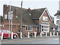
1
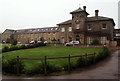
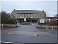
The Pines, Boston Road, Sleaford, Lincs.
This large house and office/s, together with a warehouse facing Boston Road – all constructed in yellow Yewerby brick - was laid out as a nursery and seedsmen's collection centre for John Sharp c.1830. Later on, c.1880, it was greatly enlarged for Charles Sharp who specialised in dealing in seeds. All the buildings on the site, that is known as “The Pines”, are Grade II-listed.
Image: © David Hallam-Jones
Taken: 29 Nov 2014
0.05 miles
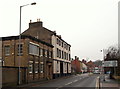
2
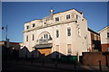
Flicks
Originally Sleaford Picturedrome cinema built in 1920, it was a snooker hall for many years but has now closed as its latest incarnation as Flicks nightclub
Image: © Richard Croft
Taken: 18 Jan 2011
0.05 miles
4
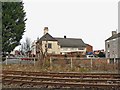
Sleaford Junction (pre-development), Sleaford (7)
The level crossing is immediately to the left of this view and South Gate straight ahead. The buildings in view include a Builder's Supply yard and the local cinema, now dis-used and just in view, to the left of that.
Image: © Mick Lobb
Taken: 24 Jan 2009
0.06 miles
5
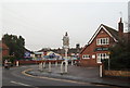
Boston Road, Sleaford, Lincs.
Boston Road, 99% of which lies behind the photographer and outside the town's boundary peters out here as motorists join the B1517 (South Gate) ahead. By the street lamp nearest the photographer is part of "The Pines". This large house, office/s and a seed warehouse was laid out as a nursery and seedsmen's collection centre for John Sharp c.1830. Later on, c.1880, it was greatly enlarged for Charles Sharp who specialised in dealing in seeds. This two storey building, together with the main house and offices (neither of which are visible here) have all been converted in apartments.
Image: © David Hallam-Jones
Taken: 29 Nov 2014
0.06 miles
6
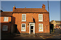
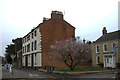
41 Boston Road
Grade II listed, early 19th century house on Boston Road
Image: © Richard Croft
Taken: 23 Jan 2014
0.06 miles
8
Pharmacy, Boston Road
The old Sharpes Warehouse has been converted into a car park and shops next to the Doctors Surgery on Boston Road.
Image: © ianh
Taken: 1 Jan 2006
0.06 miles
9
Boston Road, Sleaford, Lincs.
Boston Road, 99% of which lies behind the photographer and outside the town's boundary peters out here as motorists join the B1517 (South Gate) within 20 metres. Also, behind the photographer's left shoulder lies "The Pines". This large house, office/s and a warehouse in yellow Yewerby brick was laid out as a nursery and seedsmen's collection centre for John Sharp c.1830. Later on - c.1880 - it was greatly enlarged for Charles Sharp who specialised in dealing in seeds.
Image: © David Hallam-Jones
Taken: 29 Nov 2014
0.07 miles