IMAGES TAKEN NEAR TO
Boston Road, SLEAFORD, NG34 7ET
Introduction
This page details the photographs taken nearby to Boston Road, NG34 7ET by members of the Geograph project.
The Geograph project started in 2005 with the aim of publishing, organising and preserving representative images for every square kilometre of Great Britain, Ireland and the Isle of Man.

There are currently over 7.5m images from over14,400 individuals and you can help contribute to the project by visiting https://www.geograph.org.uk
Image Map
Images are licensed for reuse under creativecommons.org/licenses/by-sa/2.0
Notes
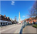
- Clicking on the map will re-center to the selected point.
- The higher the marker number, the further away the image location is from the centre of the postcode.
Image Listing (552 Images Found)
Images are licensed for reuse under creativecommons.org/licenses/by-sa/2.0
Image
Details
Distance
1
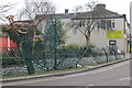
Railings - Sleaford
Artistic set of railings at the junction of Boston Rd and Southgate St.
Image: © Colin Babb
Taken: 23 Oct 2010
0.01 miles
2
NEW
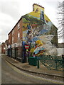
Mural - by Peachzz
Recently revealed mural brightening up this corner of Sleaford.
https://www.lincolnshireworld.com/business/mural-marks-latest-step-in-town-renovation-5027908
Image: © Ian Paterson
Taken: 12 Mar 2025
0.02 miles
3
Monument Gardens, Sleaford, Lincs.
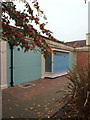
This redundant toilet block at the side of South Gate, the B1517 road, is to be converted into a museum. The Sleaford Museum Trust has received £92,000 from the Heritage Lottery Fund to establish a museum that is likely to cost £104,000. The building will give the town's collection, "which has led a wandering life since being started in the 1970s", a permanent home. these premises face the Handley Monument that is situated on the other side of South Gate.
Image: © David Hallam-Jones
Taken: 29 Nov 2014
0.03 miles
4
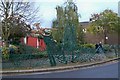
Richard Bett's 2001 Dragon Fence, South Gate
Image: © Jo and Steve Turner
Taken: 10 Jan 2013
0.03 miles
5
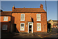
41 Boston Road
Grade II listed, early 19th century house on Boston Road
Image: © Richard Croft
Taken: 23 Jan 2014
0.03 miles
6

Benchmark on Handley Monument
Ordnance Survey cut mark benchmark levelled at 15.462m above Newlyn Datum in 1956 verified 1965. The mark was previously levelled at 51.409 feet above Liverpool Datum during the London to Doncaster 1GL Survey of 21 June 1848 - 18 December 1851. The surveyor's description was 'No. 786. Mark on South-east side of Hanley's Monument, South-street, Sleaford ; 1.31 ft. above surface'
Image: © Roger Templeman
Taken: 27 Jun 2023
0.03 miles
7
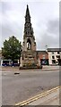
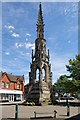
The Handley Monument at junction of South Gate and Boston Road
There is an Ordnance Survey benchmark Image on the centre of the monument's base
Image: © Roger Templeman
Taken: 27 Jun 2023
0.03 miles
8
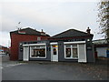
Hair and beauty salon, Handley Street
Image: © Jonathan Thacker
Taken: 20 Oct 2017
0.04 miles
9
South Gate, Sleaford
Monument to the local MP, Henry Handley, who served for nine years. He died in 1846.
Image: © Dave Hitchborne
Taken: 24 Jun 2015
0.04 miles