IMAGES TAKEN NEAR TO
Northgate, SLEAFORD, NG34 7EL
Introduction
This page details the photographs taken nearby to Northgate, NG34 7EL by members of the Geograph project.
The Geograph project started in 2005 with the aim of publishing, organising and preserving representative images for every square kilometre of Great Britain, Ireland and the Isle of Man.

There are currently over 7.5m images from over14,400 individuals and you can help contribute to the project by visiting https://www.geograph.org.uk
Image Map
Images are licensed for reuse under creativecommons.org/licenses/by-sa/2.0
Notes
- Clicking on the map will re-center to the selected point.
- The higher the marker number, the further away the image location is from the centre of the postcode.
Image Listing (511 Images Found)
Images are licensed for reuse under creativecommons.org/licenses/by-sa/2.0
Image
Details
Distance
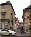
1
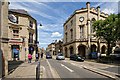
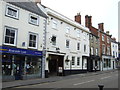
North Gate, Sleaford
Photographed from outside the HSBC, or should I say, the Hongkong and Shanghai Banking Corporation. I bet most folks not in the know would guess it was safe to put their money in somewhere like the, Halifax, Sheffield and Barnsley Corporation, or even the Halifax, Sheffield, Barnsley and Chesterfield bank. I think the building across the road is Lloyds bank.
Image: © Dave Hitchborne
Taken: 24 Jun 2015
0.00 miles
2
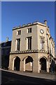
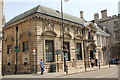
Sessions House, Market Place
Grade II* Listed Town Hall and Sessions House designed by London architect Henry Edward Kendall and built by Charles Kirk in 1831 who then decided to stay in Sleaford forming a partnership with Thomas Parry some years later. The building was put up for sale in 2008 when all court cases were transferred to Grantham Magistrates' Court.
Image: © Jo and Steve Turner
Taken: 9 Jan 2013
0.01 miles
3
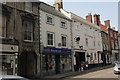
![North Gate, Sleaford [B1518]](https://s0.geograph.org.uk/geophotos/06/57/91/6579144_968d7bb1_120x120.jpg)
North Gate, Sleaford [B1518]
Looking north from the junction with Westgate, Southgate and Eastgate.
Image: © Christine Johnstone
Taken: 14 Aug 2020
0.01 miles
4
The Packhorse Inn, Northgate, Sleaford
Built in the early 18th century, this pub was one of Sleaford's old coaching inns.
Image: © PAUL FARMER
Taken: 28 Nov 2011
0.01 miles
6
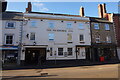
5 and 7 North Gate, Sleaford
Part of a row of 18th century Grade II Listed buildings. The Packhorse Inn is listed as the Lion Hotel. One of the early coaching inns it appears on the map of Sleaford, drawn around 1770 as The Packhorse Inn. It was also known as The White Lion, in its early days, but was recorded in a commercial directory of 1830 as The Lion Hotel and Posting House. The publican in 1872 was recorded as John Sewards. It remained The Lion Hotel until its recent closure. As the Lion Hotel it hosted the opening dinner for the Sleaford Railway, an event that marked the start of the decline in coaching trade.
Image: © Jo and Steve Turner
Taken: 12 Jul 2013
0.01 miles
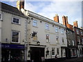
7
Lloyds Bank, 2 North Gate, Sleaford
The bank comprises two Grade II Listed buildings. Southern, farthest part is late 17th century and the more modern north section has a rain water head on Market Street dated 1904. In December 2010 the building was sold by auction for £0.55m with the sitting tenants Lloyds TSB (rent £32,500pa) whose lease expires in 2021.
Image: © Jo and Steve Turner
Taken: 12 Jul 2013
0.01 miles
8
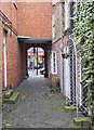
Parry's Court, Sleaford, Lincs.
Nos 6,7 and 8 in this narrow courtyard collection are Grade II-listed. They are mid C18th and mid C19th residential properties. Kirk and Parry were partners in a local architecture and builder's enterprise. The street in the distance is North Gate (the B1518 road).
Image: © David Hallam-Jones
Taken: 29 Nov 2014
0.01 miles
9
Market Street, Sleaford, Lincs.
A picture taken from outside The Packhorse Inn. On the opposite side of North gate (the B1518 road) is Market Street, leading to Market Place and St Denys Church.
Image: © David Hallam-Jones
Taken: 29 Nov 2014
0.02 miles