IMAGES TAKEN NEAR TO
Bristol Way, SLEAFORD, NG34 7AE
Introduction
This page details the photographs taken nearby to Bristol Way, NG34 7AE by members of the Geograph project.
The Geograph project started in 2005 with the aim of publishing, organising and preserving representative images for every square kilometre of Great Britain, Ireland and the Isle of Man.

There are currently over 7.5m images from over14,400 individuals and you can help contribute to the project by visiting https://www.geograph.org.uk
Image Map
Images are licensed for reuse under creativecommons.org/licenses/by-sa/2.0
Notes
- Clicking on the map will re-center to the selected point.
- The higher the marker number, the further away the image location is from the centre of the postcode.
Image Listing (17 Images Found)
Images are licensed for reuse under creativecommons.org/licenses/by-sa/2.0
Image
Details
Distance

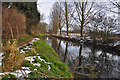
3

The River Slea - Sleaford
It is at this point that the Slea first enters the populated area of the town after leaving fields lying to the west.
Image: © Mick Lobb
Taken: 23 Dec 2009
0.10 miles
4

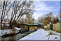
Red brick bridge beside the River Slea - Sleaford
Image: © Mick Lobb
Taken: 23 Dec 2009
0.11 miles
5
Railway bridge over the River Slea - Sleaford
The bridge carries the north/east line into and out of Sleaford.
Image: © Mick Lobb
Taken: 23 Dec 2009
0.11 miles
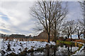
6
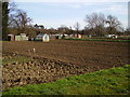
Drove Allotments provided by Sleaford Town Council
Image: © Ken Brockway
Taken: 10 Mar 2007
0.12 miles
7
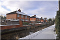
Rauceby Banks on the River Slea - Sleaford
Image: © Mick Lobb
Taken: 23 Dec 2009
0.13 miles
10
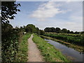
River Slea
River Slea and footpath heading towards Sleaford
Image: © Debbie J
Taken: 2 Sep 2013
0.15 miles