IMAGES TAKEN NEAR TO
Nassington Way, NG34 6AG
Introduction
This page details the photographs taken nearby to Nassington Way, NG34 6AG by members of the Geograph project.
The Geograph project started in 2005 with the aim of publishing, organising and preserving representative images for every square kilometre of Great Britain, Ireland and the Isle of Man.

There are currently over 7.5m images from over14,400 individuals and you can help contribute to the project by visiting https://www.geograph.org.uk
Image Map
Images are licensed for reuse under creativecommons.org/licenses/by-sa/2.0
Notes
- Clicking on the map will re-center to the selected point.
- The higher the marker number, the further away the image location is from the centre of the postcode.
Image Listing (25 Images Found)
Images are licensed for reuse under creativecommons.org/licenses/by-sa/2.0
Image
Details
Distance
1
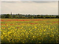
Shades of Silk Willoughby
View across the field towards Silk Willoughby, where the poppies are popping up through the rape seed.
Image: © Ian Paterson
Taken: 5 Jun 2009
0.00 miles
2
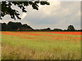
Poppy Field near Stump Cross Hill
Looking towards Sleaford over a field of red.
Image: © Ian Paterson
Taken: 21 Jun 2009
0.02 miles
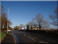
3
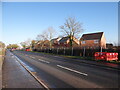
New houses under construction at Stump Cross Hill
Looking along the road in the direction of Sleaford.
Image: © Ian Paterson
Taken: 24 Dec 2022
0.03 miles
4
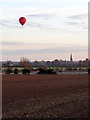
Silk Willoughby fly-past
Early spring Friday evening's flight coming in to land on a field near you.
ie the field here Image
Image: © Ian Paterson
Taken: 27 Mar 2015
0.04 miles
5
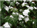
New year snow
Snow-capped ivy clings to the trunk of one of the preserved trees in this small triangular wooded area at the south side of the junction of Town Road and London Road.
Image: © Ian Paterson
Taken: 5 Jan 2010
0.09 miles
6
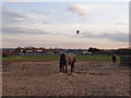
Grazing the sky
Virgin balloon flies past en route to the next square Image
Image: © Ian Paterson
Taken: 27 Mar 2015
0.09 miles
7
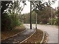
Sleaford quality control
The newly-constructed footpath, rather than by-pass the existing telegraph pole, goes right through it, rendering it useless for mobility scooters. See https://www.sleafordstandard.co.uk/news/politics/crazy-paving-gaff-on-new-sleaford-area-footpath-1-9097996.
Thankfully, the pole has been re-erected since, only a few feet to the south, but wouldn't it have been more cost effective to simply re-route the path?
Were the same folks were responsible for this quality control gaffe Image I wonder?
Image: © Ian Paterson
Taken: 27 Sep 2019
0.10 miles
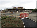
8
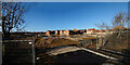
More new houses
This development lies south of Town Road.
Image: © Ian Paterson
Taken: 24 Dec 2022
0.11 miles
9
Care Home taking shape
Behind the hedge near the Town Road junction to the middle right of the photo can be seen the construction of a new Care Home.
Image: © Ian Paterson
Taken: 24 Dec 2022
0.11 miles
10
New development off Town Road
Sleaford is expanding rapidly at the moment.
Image: © Jonathan Thacker
Taken: 13 Jul 2019
0.11 miles