IMAGES TAKEN NEAR TO
Tannery Lane, SLEAFORD, NG34 0TS
Introduction
This page details the photographs taken nearby to Tannery Lane, NG34 0TS by members of the Geograph project.
The Geograph project started in 2005 with the aim of publishing, organising and preserving representative images for every square kilometre of Great Britain, Ireland and the Isle of Man.

There are currently over 7.5m images from over14,400 individuals and you can help contribute to the project by visiting https://www.geograph.org.uk
Image Map
Images are licensed for reuse under creativecommons.org/licenses/by-sa/2.0
Notes
- Clicking on the map will re-center to the selected point.
- The higher the marker number, the further away the image location is from the centre of the postcode.
Image Listing (299 Images Found)
Images are licensed for reuse under creativecommons.org/licenses/by-sa/2.0
Image
Details
Distance
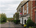
1
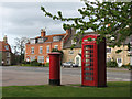
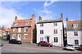
Folkingham: Market Place
Pillar box, telephone kiosk, some very handsome houses and the A15.
Image: © John Sutton
Taken: 9 May 2010
0.03 miles
2
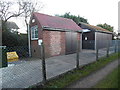
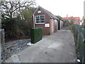
Folkingham Telephone Exchange (2)
Located on the A15 Sleaford Road, this TE serves Folkingham plus Braceby, Haceby, Laughton, Newton, Pickworth and Walcot nearby. A yellow grit salt bin can be seen to the left of the photo with a green cabinet adjacent to it. The numbering range of this TE is (01529) 497xxx, the (01529) referring to the Sleaford group of TEs, and its postcode is NG34 0SB.
Image: © David Hillas
Taken: 30 Jan 2016
0.03 miles
3
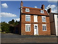
Window tax?
Georgian style house in Folkingham, with what appears to be a bricked up central window. Note that the number of windows on the frontage is 6. The window tax of 1696 was levied on houses with ten or more windows. In 1766 this was extended to seven windows and above. The tax was abolished in 1851.
But the tax was levied on all openings, including the rear. So its quite possible this blank window is decorative, not financial.
See https://www.parliament.uk/about/living-heritage/transformingsociety/towncountry/towns/tyne-and-wear-case-study/about-the-group/housing/window-tax/
Image: © Bob Harvey
Taken: 7 Sep 2014
0.03 miles
4
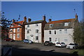
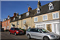
16 to 10 The Market Place, Folkingham
Grade II Listed properties. Left to right, 16 is late 18th century. 14 is early 18th century and the pair of semi-detached houses are late 18th century. All of the houses have had 20th century alterations.
Image: © Jo and Steve Turner
Taken: 24 Mar 2017
0.03 miles
5
Houses on the hill
These are all listed buildings, but at least they are not listing with the slope. they are part of the delightful Georgian miscellany of Folkingham Market Place.
From left to right https://historicengland.org.uk/listing/the-list/list-entry/1360149 https://historicengland.org.uk/listing/the-list/list-entry/1317284 https://historicengland.org.uk/listing/the-list/list-entry/1062742
Image: © Bob Harvey
Taken: 5 Sep 2020
0.03 miles
6
Folkingham Telephone Exchange (1)
Situated on the A15 Sleaford Road, this TE comprises of the front redbrick building which dates from the GPO era, whilst the dark wooden building behind it was added more recently presumably to cope with the increase in telephone traffic. A BT warning notice can be seen on the front of the redbrick building whilst a green cabinet has been installed in the foreground.
Image: © David Hillas
Taken: 30 Jan 2016
0.03 miles
7
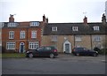
30 - 38 Market Place, Folkingham
A row of 5 Grade II Listed dwellings. Nearest, number 30, former house with shop is early 18th century. 32 and 34 now two cottages were the former village jail and court house, built in the 17th century. This building was the village House of Correction from 1609 until 1808, when the second House of Correction was built. The able-bodied poor were gathered and put to work here by the constable. There was also a gaol beneath the building. This consisted of four 10 feet square cells for men and two for women, as well as a day room. A Keeper's house is also mentioned, which was situated above the gaol. The exercise yard for prisoners was situated in the market place. The red brick 36 and 38 are late 18th century.
Image: © Jo and Steve Turner
Taken: 24 Mar 2017
0.04 miles
8

Georgian splendour
Grade II listed buildings at the side of the A15 road.
The red brick buildings date from the late 18th century, and the limestone one on the right is 150 years older, and was at one time the gaol and courthouse.
See https://historicengland.org.uk/listing/the-list/list-entry/1317226 , https://historicengland.org.uk/listing/the-list/list-entry/1360111 , https://historicengland.org.uk/listing/the-list/list-entry/1317261
Image: © Bob Harvey
Taken: 18 Sep 2020
0.04 miles
10
Folkingham: Market Place
"The centre of the village," wrote Nikolaus Pevsner, "is the exceptionally spacious square, a long oblong going gently down the hillside. Its scale is due to the fact that Folkingham used to be a seat of Quarter Sessions.... The houses flanking the square are of brick or, more often, stone. Nice doorcases."
Image: © John Sutton
Taken: 9 May 2010
0.04 miles