IMAGES TAKEN NEAR TO
Walcot Lane, SLEAFORD, NG34 0TP
Introduction
This page details the photographs taken nearby to Walcot Lane, NG34 0TP by members of the Geograph project.
The Geograph project started in 2005 with the aim of publishing, organising and preserving representative images for every square kilometre of Great Britain, Ireland and the Isle of Man.

There are currently over 7.5m images from over14,400 individuals and you can help contribute to the project by visiting https://www.geograph.org.uk
Image Map
Images are licensed for reuse under creativecommons.org/licenses/by-sa/2.0
Notes
- Clicking on the map will re-center to the selected point.
- The higher the marker number, the further away the image location is from the centre of the postcode.
Image Listing (48 Images Found)
Images are licensed for reuse under creativecommons.org/licenses/by-sa/2.0
Image
Details
Distance
1
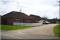
Shared access
A pair of bungalows, two of 4 that share this gravel track
Image: © Bob Harvey
Taken: 14 Apr 2018
0.00 miles


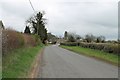
9

The edge of the village
The end of Wilkie Drive in Walcot Road, with the playing fields opposite
Image: © Bob Harvey
Taken: 14 Apr 2018
0.07 miles
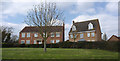
10

Wilkie Drive, Folkingham
Part of a new area of short residential streets on the west side of the village.
Image: © Des Blenkinsopp
Taken: 26 Mar 2014
0.07 miles