IMAGES TAKEN NEAR TO
Mill Lane, SLEAFORD, NG34 0TE
Introduction
This page details the photographs taken nearby to Mill Lane, NG34 0TE by members of the Geograph project.
The Geograph project started in 2005 with the aim of publishing, organising and preserving representative images for every square kilometre of Great Britain, Ireland and the Isle of Man.

There are currently over 7.5m images from over14,400 individuals and you can help contribute to the project by visiting https://www.geograph.org.uk
Image Map
Images are licensed for reuse under creativecommons.org/licenses/by-sa/2.0
Notes
- Clicking on the map will re-center to the selected point.
- The higher the marker number, the further away the image location is from the centre of the postcode.
Image Listing (128 Images Found)
Images are licensed for reuse under creativecommons.org/licenses/by-sa/2.0
Image
Details
Distance
1
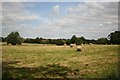
Pickworth farmland
View from St.Andrew's churchyard
Image: © Richard Croft
Taken: 9 Aug 2007
0.12 miles
2
Pickworth
View from St.Andrew's churchyard
Image: © Richard Croft
Taken: 9 Aug 2007
0.12 miles
3
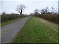
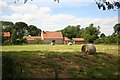
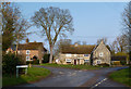
Mill Lane near Pickworth
Mill Lane rises out of Pickworth to the north, to pass Pickworth Mill. The mill can just be glimpsed through the trees to the right of the lane.
Image: © Marathon
Taken: 1 Mar 2015
0.13 miles
4
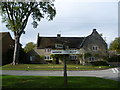
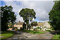
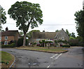
In the centre of Pickworth
Pickworth is a small village with a population of about 200 people. At its centre is a small triangular green where Village Street, Church Lane and Mill Lane meet. This attractive house fronts on to the green.
Image: © Marathon
Taken: 26 Sep 2011
0.13 miles
5
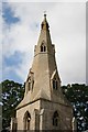
Broach Spire
Late 14th century broach spire with 3 tiers of alternating lucarnes - graceful proportions !
Image: © Richard Croft
Taken: 9 Aug 2007
0.14 miles
6
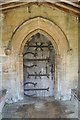
South door
South doorway to St.Andrew's church. A complete 14th century doorway with elaborate decorative ironwork ... the letter C shape honours St.Clement the Martyr, Patron Saint of blacksmiths
Image: © Richard Croft
Taken: 9 Aug 2007
0.14 miles
7
Pickworth
Pica's enclosure (Old English personal name + worth) http://kepn.nottingham.ac.uk/map/place/Lincolnshire/Pickworth. The village leading to a surname. "Pica" may originally have been a nickname for a tall thin person, from a Germanic element meaning "sharp" or "pointed" https://www.surnamedb.com/Surname/Pickworth
Image: © Tim Heaton
Taken: 29 Sep 2021
0.14 miles
9
Grass triangle
The junction, with fingerpost and grass triangle in the middle of Pickworth
Image: © Bob Harvey
Taken: 12 Aug 2018
0.14 miles
10
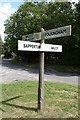
Old Direction Sign - Signpost by Village Street, Pickworth Parish
No finial - 4 arms; by the UC road, in parish of Pickworth (South Kesteven District), junction of Village Street and Mill Lane, on grass triangle.
Surveyed
Milestone Society National ID: LI_TF0433
Image: © Milestone Society
Taken: Unknown
0.14 miles