IMAGES TAKEN NEAR TO
Pointon Road, SLEAFORD, NG34 0LP
Introduction
This page details the photographs taken nearby to Pointon Road, NG34 0LP by members of the Geograph project.
The Geograph project started in 2005 with the aim of publishing, organising and preserving representative images for every square kilometre of Great Britain, Ireland and the Isle of Man.

There are currently over 7.5m images from over14,400 individuals and you can help contribute to the project by visiting https://www.geograph.org.uk
Image Map
Images are licensed for reuse under creativecommons.org/licenses/by-sa/2.0
Notes
- Clicking on the map will re-center to the selected point.
- The higher the marker number, the further away the image location is from the centre of the postcode.
Image Listing (3 Images Found)
Images are licensed for reuse under creativecommons.org/licenses/by-sa/2.0
Image
Details
Distance

3
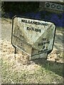
Old Milestone, on the B1177, Pointon Road
Located on the West side of road, on the verge. Cast iron post, Billingboro iron casting design, erected by Donington to Hacconbury Field, SE District turnpike trust, 19th century.
Inscription reads: // TO / BILLINGBORO / 1 / MILE //TO / BOURNE / 9 / MILES //BILLINGBORO / PARISH //.
Grade II listed by Historic England. see https://historicengland.org.uk/listing/the-list/list-entry/1317550
Milestone Society National ID: LI_BIBN01
Image: © Milestone Society
Taken: Unknown
0.07 miles