IMAGES TAKEN NEAR TO
Ousemere Close, SLEAFORD, NG34 0HY
Introduction
This page details the photographs taken nearby to Ousemere Close, NG34 0HY by members of the Geograph project.
The Geograph project started in 2005 with the aim of publishing, organising and preserving representative images for every square kilometre of Great Britain, Ireland and the Isle of Man.

There are currently over 7.5m images from over14,400 individuals and you can help contribute to the project by visiting https://www.geograph.org.uk
Image Map
Images are licensed for reuse under creativecommons.org/licenses/by-sa/2.0
Notes
- Clicking on the map will re-center to the selected point.
- The higher the marker number, the further away the image location is from the centre of the postcode.
Image Listing (69 Images Found)
Images are licensed for reuse under creativecommons.org/licenses/by-sa/2.0
Image
Details
Distance


4

Bridge in Billingborough
This bridge crosses the Ouse Mere Lode by the primary school on Victoria Street.
Image: © Kate Jewell
Taken: 1 May 2007
0.10 miles
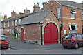
6

The old fire station at Billingborough, near Bourne, Lincolnshire
The odd building at the corner of Vine Street and Victoria Street in Billingborough is the old village fire station, built in 1890 and used to house a horse-drawn hand pump for the next fifty years but it was eventually phased out and retired to the county fire brigade museum. The fire station has been preserved as a curiosity although the wooden bus shelter attached to the outside wall has now been removed.
Image: © Rex Needle
Taken: 14 Jun 2000
0.11 miles
7
Billingborough old fire station
Billingborough fire station, Vine Street, Billingborough, Lincolnshire, which was replaced by Image The station dates from 1890, and lasted until the 1970s. It has recently been refurbished by the present owner who lives in the adjacent house.
Image: © Kevin Hale
Taken: 31 May 2008
0.11 miles
8
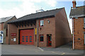
Billingborough fire station
Billingborough fire station, 8 High Street, Billingborough, Lincolnshire
Image: © Kevin Hale
Taken: 31 May 2008
0.11 miles
9
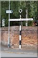
Old Direction Sign - Signpost by the B1177, High Street, Billingborough
Annulus finial - 2 arms; Kesteven CC halo by the B1177, in parish of Billingborough (South Kesteven District), junction of Vine Street with High Street, on footway.
Surveyed
Milestone Society National ID: LI_TF1134
Image: © Milestone Society
Taken: Unknown
0.11 miles
10

Billingborough & Horbling railway station (site), Lincolnshire
Opened in 1872 by the Bourne and Sleaford Railway which was part of the Great Northern Railway empire, this station closed to passengers in 1930 and completely in 1964.
View south towards Rippingale and Bourne. As with other former stations on the line, it is now a private residence.
Image: © Nigel Thompson
Taken: 11 Nov 2012
0.12 miles