IMAGES TAKEN NEAR TO
Graby, SLEAFORD, NG34 0HS
Introduction
This page details the photographs taken nearby to NG34 0HS by members of the Geograph project.
The Geograph project started in 2005 with the aim of publishing, organising and preserving representative images for every square kilometre of Great Britain, Ireland and the Isle of Man.

There are currently over 7.5m images from over14,400 individuals and you can help contribute to the project by visiting https://www.geograph.org.uk
Image Map
Images are licensed for reuse under creativecommons.org/licenses/by-sa/2.0
Notes
- Clicking on the map will re-center to the selected point.
- The higher the marker number, the further away the image location is from the centre of the postcode.
Image Listing (11 Images Found)
Images are licensed for reuse under creativecommons.org/licenses/by-sa/2.0
Image
Details
Distance
1

Entering Graby
A small farming community in South Lincolnshire.
Image: © Jonathan Billinger
Taken: 27 Oct 2010
0.03 miles
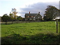
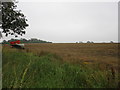
2
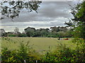
Beast field
Cattle in field at Graby Manor
Image: © Bob Harvey
Taken: 30 Sep 2012
0.15 miles
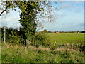
3
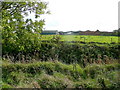
Farm buildings and pasture land
Looking south near Graby.
Image: © Jonathan Billinger
Taken: 27 Oct 2010
0.16 miles
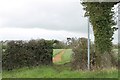
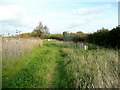
6
Footpath to Graby
Old stubble land left fallow in the field.
Image: © Jonathan Billinger
Taken: 27 Oct 2010
0.18 miles
7
Harvested field at Graby
Looks to have been a field of oilseed rape.
Image: © Jonathan Thacker
Taken: 28 Jul 2019
0.20 miles
8
Field edge with game feeders
Typical rural South Lincolnshire scene.
Image: © Jonathan Billinger
Taken: 27 Oct 2010
0.23 miles
9
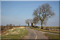
Mareham Lane
The course of Mareham Lane Roman Road near Graby
Image: © Richard Croft
Taken: 1 Mar 2012
0.23 miles
