IMAGES TAKEN NEAR TO
Bourne Road, SLEAFORD, NG34 0HA
Introduction
This page details the photographs taken nearby to Bourne Road, NG34 0HA by members of the Geograph project.
The Geograph project started in 2005 with the aim of publishing, organising and preserving representative images for every square kilometre of Great Britain, Ireland and the Isle of Man.

There are currently over 7.5m images from over14,400 individuals and you can help contribute to the project by visiting https://www.geograph.org.uk
Image Map
Images are licensed for reuse under creativecommons.org/licenses/by-sa/2.0
Notes
- Clicking on the map will re-center to the selected point.
- The higher the marker number, the further away the image location is from the centre of the postcode.
Image Listing (15 Images Found)
Images are licensed for reuse under creativecommons.org/licenses/by-sa/2.0
Image
Details
Distance
3
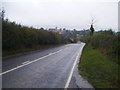
Bourne Road (A15)
Heading north towards Sleaford.
Image: © JThomas
Taken: 12 Oct 2013
0.05 miles
5
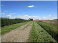
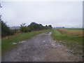
Brickyard Lane, Folkingham
A restricted byway.
Image: © Jonathan Thacker
Taken: 24 Aug 2020
0.10 miles
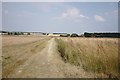
6
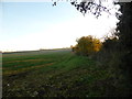
The mist is rising
Late afternoon and falling temperatures caress the fields with rising swirls of mist, intangible and evocative.
Image: © Bob Harvey
Taken: 1 Dec 2013
0.11 miles
7
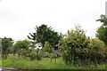
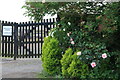
Garden on South Street, Bourne
It belongs to the house but designed like a park
Image: © David Howard
Taken: 24 Jun 2019
0.19 miles
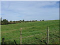
10
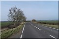
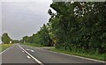
A main road
This is the A15, the main road from Peterborough to Lincoln.
Image: © Bob Harvey
Taken: 13 Mar 2016
0.23 miles