IMAGES TAKEN NEAR TO
Sandygate Court, SLEAFORD, NG34 0FB
Introduction
This page details the photographs taken nearby to Sandygate Court, NG34 0FB by members of the Geograph project.
The Geograph project started in 2005 with the aim of publishing, organising and preserving representative images for every square kilometre of Great Britain, Ireland and the Isle of Man.

There are currently over 7.5m images from over14,400 individuals and you can help contribute to the project by visiting https://www.geograph.org.uk
Image Map
Images are licensed for reuse under creativecommons.org/licenses/by-sa/2.0
Notes
- Clicking on the map will re-center to the selected point.
- The higher the marker number, the further away the image location is from the centre of the postcode.
Image Listing (41 Images Found)
Images are licensed for reuse under creativecommons.org/licenses/by-sa/2.0
Image
Details
Distance
1
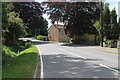
High Street, Horbling
Heading south.
Image: © J.Hannan-Briggs
Taken: 6 Jun 2015
0.07 miles
2
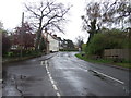
High Street (B1177), Horbling, heading north
Image: © JThomas
Taken: 27 Apr 2012
0.07 miles
3
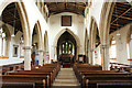
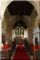
St.Andrew's nave
View east in the grade I listed St.Andrew's church towards the misshapen crossing arch and 13th century arcades
Image: © Richard Croft
Taken: 9 Apr 2015
0.09 miles
4
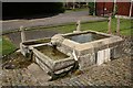
Spring Well
On the appropriately named Spring Lane, water rises in a central cistern which in turn feeds three smaller and lower troughs. A plaque nearby reads "In 1711 the constables of Horbling paid £9 15s 5d to Anthony Ashley of Stamford to construct this well and maintain it for 20 years. In January 1998 the wells were restored by E.Bowman & Sons of Stamford at a cost of £5,600 using parish funds and grant assistance"
Image: © Richard Croft
Taken: 26 May 2009
0.10 miles
5
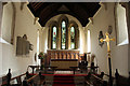
St.Andrew's chancel
View east in St.Andrew's chancel
Image: © Richard Croft
Taken: 9 Apr 2015
0.10 miles
6
St.Andrew's crossing
View east through the crossing to the chancel in St.Andrew's church. The central tower doesn't have a ringing chamber, so the bell ropes extend to the crossing and the ringers perform in front of the congregation.
Image: © Richard Croft
Taken: 9 Apr 2015
0.10 miles
7
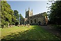
The Church of St Andrew, Horbling
This church was nineteenth on the list to be photographed on this day - http://www.geograph.org.uk/photo/3624846 The church is of cruciform construction in Norman, Early English and later styles. It comprises a chancel, clerestoried nave, aisles, transepts and embattled tower with pinnacles and five bells. The chancel contains a piscina and sedilia, and Norman arcading in the west front. The tower, owing to bad foundations was successively rebuilt or repaired in transitional, Early English and early Decorated periods. The north aisle and transept are late Decorative, as is the font. The south aisle and transept, and clerestory, are Perpendicular.
Image: © Dave Hitchborne
Taken: 26 Aug 2013
0.10 miles
8
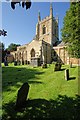
The Church of St Andrew, Horbling
This church was nineteenth on the list to be photographed on this day - http://www.geograph.org.uk/photo/3624846 The church is of cruciform construction in Norman, Early English and later styles. It comprises a chancel, clerestoried nave, aisles, transepts and embattled tower with pinnacles and five bells. The chancel contains a piscina and sedilia, and Norman arcading in the west front. The tower, owing to bad foundations was successively rebuilt or repaired in transitional, Early English and early Decorated periods. The north aisle and transept are late Decorative, as is the font. The south aisle and transept, and clerestory, are Perpendicular.
Image: © Dave Hitchborne
Taken: 26 Aug 2013
0.10 miles
9
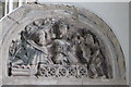
Easter Sepulchre carving, St Andrew's church, Horbling
Carving of Christ rising from the tomb above a possible Easter Sepulchre and tomb niche.
Image: © J.Hannan-Briggs
Taken: 6 Jun 2015
0.10 miles
10
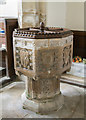
Font, St Andrew's church, Horbling
Carved with shields showing instruments of the passion.
Image: © J.Hannan-Briggs
Taken: 6 Jun 2015
0.10 miles