IMAGES TAKEN NEAR TO
Beacon Hill, SLEAFORD, NG34 0EY
Introduction
This page details the photographs taken nearby to Beacon Hill, NG34 0EY by members of the Geograph project.
The Geograph project started in 2005 with the aim of publishing, organising and preserving representative images for every square kilometre of Great Britain, Ireland and the Isle of Man.

There are currently over 7.5m images from over14,400 individuals and you can help contribute to the project by visiting https://www.geograph.org.uk
Image Map
Images are licensed for reuse under creativecommons.org/licenses/by-sa/2.0
Notes
- Clicking on the map will re-center to the selected point.
- The higher the marker number, the further away the image location is from the centre of the postcode.
Image Listing (8 Images Found)
Images are licensed for reuse under creativecommons.org/licenses/by-sa/2.0
Image
Details
Distance
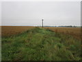
2
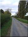
Mareham Lane heading north
On the Roman Road towards Sleaford.
Image: © JThomas
Taken: 26 Oct 2013
0.05 miles
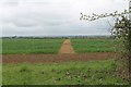
3
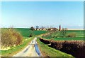
Farmstead at Aslackby, near Bourne, Lincolnshire
There can be no greater pleasure than leaving the main roads in the fens and driving through byways usually confined to farm vehicles such as this old Roman road to the north of Aslackby where there is a peace and quiet in the countryside unknown in urban areas.
Image: © Rex Needle
Taken: 18 Mar 2000
0.07 miles
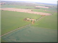
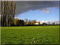
4
Farmland, Beacon Hill Farm
Off the old Roman Road.
Image: © JThomas
Taken: 26 Oct 2013
0.09 miles
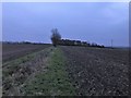
5
Rough track near Beacon Hill Farm
OS shows this as a track but it doesn't look to be used.
Image: © Jonathan Thacker
Taken: 28 Jul 2019
0.14 miles
6
Footpath off Mareham Lane at Beacon Hill
Image: © J.Hannan-Briggs
Taken: 8 Apr 2012
0.15 miles
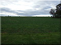
8
Farmland on Beacon Hill
This path is now part of the Cross-Britain Way which was established in 2014. The 2015 Explorer map (248) I was carrying doesn't even recognize it as a footpath.
Image: © Jonathan Clitheroe
Taken: 21 Nov 2019
0.15 miles