
IMAGES TAKEN NEAR TO
Newton, SLEAFORD, NG34 0DZ
Introduction
This page details the photographs taken nearby to NG34 0DZ by members of the Geograph project.
The Geograph project started in 2005 with the aim of publishing, organising and preserving representative images for every square kilometre of Great Britain, Ireland and the Isle of Man.

There are currently over 7.5m images from over14,400 individuals and you can help contribute to the project by visiting https://www.geograph.org.uk
Image Map
Images are licensed for reuse under creativecommons.org/licenses/by-sa/2.0
Notes
- Clicking on the map will re-center to the selected point.
- The higher the marker number, the further away the image location is from the centre of the postcode.
Image Listing (65 Images Found)
Images are licensed for reuse under creativecommons.org/licenses/by-sa/2.0
Image
Details
Distance
1
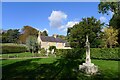
Village Cross, The Green, Newton
Listed Grade II 'buildings': a 19th century cross and, behind, the late 18th century Laundry Cottage https://historicengland.org.uk/listing/the-list/map-search?clearresults=true?clearresults=True#?search=TF04723626
Image: © Tim Heaton
Taken: 10 Oct 2022
0.08 miles
5
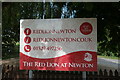
Sign for the Red Lion
There are 3 of these modern enamelled signs, all arranged differently.
Image: © Bob Harvey
Taken: 16 Aug 2016
0.10 miles
7
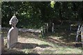
The Church of St. Botolph: A change of levels
The village is built within a steep little river valley, so it is devoid of wide flat expanses, but this change in level within the churchyard is interesting. During the 19th century restoration the churchyard wall seen on the left was removed to extend the graveyard into the area seen on the right, which is at a lower level. Much of that change in level is natural, but the abruptness is caused by the way the medieval portion of the graveyard had risen to the top of the wall simply because so many people had been buried there.
Image: © Bob Harvey
Taken: 19 Aug 2018
0.11 miles
8
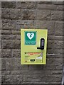
Defibrillator at the pub
The landlord at The Red Lion tells me he paid for this himself for the benefit of the village.
Note there is no location code - rather than phone for the door code, he has directly informed every villager how to open the box
Image: © Bob Harvey
Taken: 19 Aug 2018
0.11 miles
9
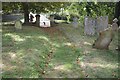
The Church of St Botolph: nature reclaims
There was once a paved path from this gate to the North Door. The vegetation and sandy soil of the churchyard has spread across the path, reclaiming it for nature.
Image: © Bob Harvey
Taken: 19 Aug 2018
0.12 miles
10
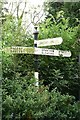
Old Direction Sign - Signpost by Haceby Road, Newton and Haceby Parish
Annulus finial - 3 arms; Kesteven CC halo by the UC road, in parish of Newton and Haceby (North Kesteven District), Haceby Road, Newton, in hedge.
Surveyed
Milestone Society National ID: LI_TF0436
Image: © Milestone Society
Taken: 1 Jan 2014
0.12 miles