IMAGES TAKEN NEAR TO
Scredington, SLEAFORD, NG34 0BW
Introduction
This page details the photographs taken nearby to NG34 0BW by members of the Geograph project.
The Geograph project started in 2005 with the aim of publishing, organising and preserving representative images for every square kilometre of Great Britain, Ireland and the Isle of Man.

There are currently over 7.5m images from over14,400 individuals and you can help contribute to the project by visiting https://www.geograph.org.uk
Image Map
Images are licensed for reuse under creativecommons.org/licenses/by-sa/2.0
Notes
- Clicking on the map will re-center to the selected point.
- The higher the marker number, the further away the image location is from the centre of the postcode.
Image Listing (5 Images Found)
Images are licensed for reuse under creativecommons.org/licenses/by-sa/2.0
Image
Details
Distance
1
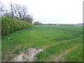
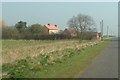
Helpringham Road
Past Poplar Farm on the right.
Image: © J.Hannan-Briggs
Taken: 6 Jun 2015
0.03 miles
2
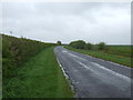
Poplar Farm
Buildings once associated with agriculture have become a des-res in the rolling farmland of South Kesteven
Image: © Donnylad
Taken: 27 Mar 2007
0.05 miles