IMAGES TAKEN NEAR TO
Burton Gorse, SLEAFORD, NG34 0BN
Introduction
This page details the photographs taken nearby to NG34 0BN by members of the Geograph project.
The Geograph project started in 2005 with the aim of publishing, organising and preserving representative images for every square kilometre of Great Britain, Ireland and the Isle of Man.

There are currently over 7.5m images from over14,400 individuals and you can help contribute to the project by visiting https://www.geograph.org.uk
Image Map
Images are licensed for reuse under creativecommons.org/licenses/by-sa/2.0
Notes
- Clicking on the map will re-center to the selected point.
- The higher the marker number, the further away the image location is from the centre of the postcode.
Image Listing (6 Images Found)
Images are licensed for reuse under creativecommons.org/licenses/by-sa/2.0
Image
Details
Distance
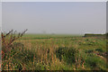
2
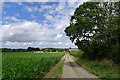
Bridleway descending from Burton Cliff
Passing a field of maize en route to the junction with Whitecross Lane
Image: © Tim Heaton
Taken: 29 Jul 2023
0.17 miles
3
Corner of waste ground - Willoughby Gorse
A few shrubs stand beside at a bend in the lane with a little patch of waste ground behind them. A nearby ditch is planted with a hedgerow along its edge.
Image: © Mick Lobb
Taken: 18 May 2010
0.23 miles
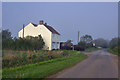
4
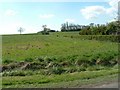
Hill Top Farm
A steeply climbing Bridleway approaches this farm in a southerly direction from Whitecross Lane
Image: © Donnylad
Taken: 18 Apr 2007
0.25 miles