IMAGES TAKEN NEAR TO
Spanby, SLEAFORD, NG34 0BG
Introduction
This page details the photographs taken nearby to NG34 0BG by members of the Geograph project.
The Geograph project started in 2005 with the aim of publishing, organising and preserving representative images for every square kilometre of Great Britain, Ireland and the Isle of Man.

There are currently over 7.5m images from over14,400 individuals and you can help contribute to the project by visiting https://www.geograph.org.uk
Image Map
Images are licensed for reuse under creativecommons.org/licenses/by-sa/2.0
Notes
- Clicking on the map will re-center to the selected point.
- The higher the marker number, the further away the image location is from the centre of the postcode.
Image Listing (5 Images Found)
Images are licensed for reuse under creativecommons.org/licenses/by-sa/2.0
Image
Details
Distance
4
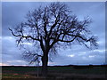
Evening tree
Silhouette of a fine tree near the public footpath.
Image: © Ian Paterson
Taken: 26 Feb 2011
0.22 miles
5
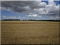
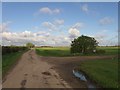
Partly harvested field
Recent heavy rain stopped harvesting and much of this field has standing water.
Looking towards Spanby Lodge.
Image: © Jonathan Thacker
Taken: 17 Aug 2019
0.23 miles