IMAGES TAKEN NEAR TO
Mareham Lane, SLEAFORD, NG34 0AW
Introduction
This page details the photographs taken nearby to Mareham Lane, NG34 0AW by members of the Geograph project.
The Geograph project started in 2005 with the aim of publishing, organising and preserving representative images for every square kilometre of Great Britain, Ireland and the Isle of Man.

There are currently over 7.5m images from over14,400 individuals and you can help contribute to the project by visiting https://www.geograph.org.uk
Image Map
Images are licensed for reuse under creativecommons.org/licenses/by-sa/2.0
Notes
- Clicking on the map will re-center to the selected point.
- The higher the marker number, the further away the image location is from the centre of the postcode.
Image Listing (10 Images Found)
Images are licensed for reuse under creativecommons.org/licenses/by-sa/2.0
Image
Details
Distance
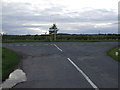
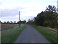
1
Mareham Lane heading north
On the Roman Road towards Sleaford.
Image: © JThomas
Taken: 26 Oct 2013
0.13 miles
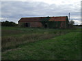
2
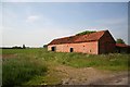
Disused farm building on Mareham Lane
Opposite Corner Cottage on Mareham Lane looking south
Image: © Richard Croft
Taken: 7 Jun 2006
0.16 miles
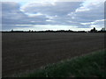
3
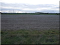
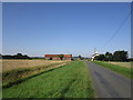
Farmland west of Mareham Lane
Off the old Roman Road.
Image: © JThomas
Taken: 26 Oct 2013
0.17 miles
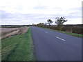
8
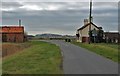
Gorse Drove
Approaching Mareham Lane. Corner Cottage on the right.
Image: © Jonathan Thacker
Taken: 26 Aug 2019
0.22 miles
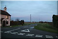
9
Junction of Gorse drove and Mareham Lane at Corner Cottage
Image: © J.Hannan-Briggs
Taken: 8 Jan 2012
0.22 miles