IMAGES TAKEN NEAR TO
Mareham Lane, SLEAFORD, NG34 0AF
Introduction
This page details the photographs taken nearby to Mareham Lane, NG34 0AF by members of the Geograph project.
The Geograph project started in 2005 with the aim of publishing, organising and preserving representative images for every square kilometre of Great Britain, Ireland and the Isle of Man.

There are currently over 7.5m images from over14,400 individuals and you can help contribute to the project by visiting https://www.geograph.org.uk
Image Map
Images are licensed for reuse under creativecommons.org/licenses/by-sa/2.0
Notes
- Clicking on the map will re-center to the selected point.
- The higher the marker number, the further away the image location is from the centre of the postcode.
Image Listing (10 Images Found)
Images are licensed for reuse under creativecommons.org/licenses/by-sa/2.0
Image
Details
Distance
1
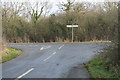
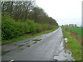
Junction of Mareham and Gorse Lanes
Turn left for Sleaford.
Image: © J.Hannan-Briggs
Taken: 13 Jan 2013
0.05 miles
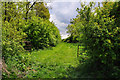
2
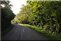
Whitecross Lane - Willoughby Gorse
At this point the lane passes between pits on Saltbox Farm.
Image: © Mick Lobb
Taken: 18 May 2010
0.06 miles
4
Junction of Gorse Lane with Mareham Lane - Silk Willoughby
Image: © Mick Lobb
Taken: 17 May 2010
0.06 miles
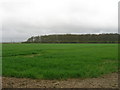
6
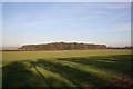
Willoughby Gorse
Autumnal colours near the Roman Road of Mareham Lane
Image: © Richard Croft
Taken: Unknown
0.15 miles
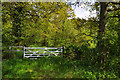
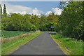
9
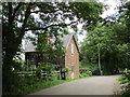
The Old Gatehouse
Former crossing keeper's cottage where Whitecross Lane crossed the Sleaford to Bourne railway line.
Image: © Jonathan Thacker
Taken: 22 Jun 2019
0.20 miles
10
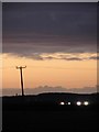
Watch the birdies
Darkness falls, but the golfers at Birdies Driving Range are still at it thanks to the floodlighting.
Image: © Ian Paterson
Taken: 26 Feb 2011
0.21 miles