IMAGES TAKEN NEAR TO
Rushworth Close, NOTTINGHAM, NG3 3PE
Introduction
This page details the photographs taken nearby to Rushworth Close, NG3 3PE by members of the Geograph project.
The Geograph project started in 2005 with the aim of publishing, organising and preserving representative images for every square kilometre of Great Britain, Ireland and the Isle of Man.

There are currently over 7.5m images from over14,400 individuals and you can help contribute to the project by visiting https://www.geograph.org.uk
Image Map
Images are licensed for reuse under creativecommons.org/licenses/by-sa/2.0
Notes
- Clicking on the map will re-center to the selected point.
- The higher the marker number, the further away the image location is from the centre of the postcode.
Image Listing (54 Images Found)
Images are licensed for reuse under creativecommons.org/licenses/by-sa/2.0
Image
Details
Distance
1
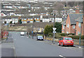
Looking down Southampton Street
Until the 1960s, St Anns was a warren of densely packed terraced housing from the first half of the 19th century. This was all swept away in a major redevelopment from the late 1960s onwards.
Image: © Alan Murray-Rust
Taken: 8 Mar 2009
0.08 miles
2
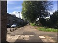
Access walkway in St Ann's Valley
Though mind social housing.
Image: © David Lally
Taken: 6 Oct 2017
0.09 miles
3
St Anns Well Primary School
On Hungerhill Road
Image: © Alan Murray-Rust
Taken: 8 Mar 2009
0.09 miles
4
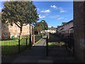
Walkway between Lotus and Luther Close
The flats on the left are on the former, on the right the latter.
Image: © David Lally
Taken: 6 Oct 2017
0.12 miles
5
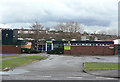
The Chase
1970s pub at the foot of Robin Hood Chase.
Image: © Alan Murray-Rust
Taken: 8 Mar 2009
0.12 miles
6
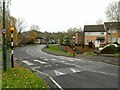
Hungerhill Road at Norland Close
Typical of the 1970s redevelopment of the St Ann's area with separation of pedestrian and vehicular traffic. The Zebra crossing in the foreground replaced the subway beyond, stopped up in around 2010 for social safety reasons. See also https://www.geograph.org.uk/photo/7351899 .
Image: © Alan Murray-Rust
Taken: 27 Nov 2022
0.12 miles
7
Broad Oak Close
Looking across the St Ann's Valley to Blue Bell Hill Road
Image: © Alan Murray-Rust
Taken: 8 Mar 2009
0.12 miles
8
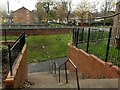
Steps down to the subway, Hungerhill Road
The subway was filled in around 2010 as a social safety measure. See also https://www.geograph.org.uk/photo/7351897 .
Image: © Alan Murray-Rust
Taken: 27 Nov 2022
0.13 miles
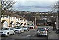
9
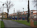
Shops at Robin Hood Chase
This is the main commercial centre of the St Anns area.
Image: © Alan Murray-Rust
Taken: 8 Mar 2009
0.13 miles
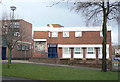
10
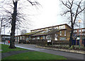
The Chase Centre
Community Centre for St Anns.
A modern building - note the deliberately vegetated roof.
Image: © Alan Murray-Rust
Taken: 8 Mar 2009
0.13 miles