IMAGES TAKEN NEAR TO
Moffat Close, NOTTINGHAM, NG3 3NL
Introduction
This page details the photographs taken nearby to Moffat Close, NG3 3NL by members of the Geograph project.
The Geograph project started in 2005 with the aim of publishing, organising and preserving representative images for every square kilometre of Great Britain, Ireland and the Isle of Man.

There are currently over 7.5m images from over14,400 individuals and you can help contribute to the project by visiting https://www.geograph.org.uk
Image Map
Images are licensed for reuse under creativecommons.org/licenses/by-sa/2.0
Notes
- Clicking on the map will re-center to the selected point.
- The higher the marker number, the further away the image location is from the centre of the postcode.
Image Listing (24 Images Found)
Images are licensed for reuse under creativecommons.org/licenses/by-sa/2.0
Image
Details
Distance
1
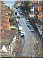
Donkey Hill
Officially St bartholomew's Road, it's always known locally by its nickname, although where this originates I do not know. The gradient is probably about 1 in 7.
Image: © Alan Murray-Rust
Taken: 8 Mar 2009
0.06 miles
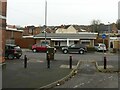
2

The V ctoria Works
The Wells Road, St Ann's
Image: © David Lally
Taken: 12 Aug 2017
0.11 miles
3
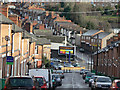
Cromer Road
Terraced housing towards the east end of St Ann's
Image: © Alan Murray-Rust
Taken: 8 Mar 2009
0.11 miles
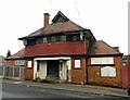
4
Heron Foods shop
Formerly "The Westminster" public house.
Image: © David Lally
Taken: 5 Jul 2016
0.12 miles
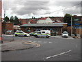
6
The former Ransom Road Police Station
Recreating this 'First' for the square https://www.geograph.org.uk/photo/43311 .
The station had closed by 2008 and was converted to two small housing units around 2010. The bottom of Cromer Road had also been stopped up for motor traffic by 2008.
Image: © Alan Murray-Rust
Taken: 27 Nov 2022
0.13 miles
7
Canon Lewis Memorial Hall, Ransom Road
Built as a church hall in Arts and Crafts style in 1907, it has been disused since 1998. Some external refurbishment work appears to have been carried out around 2008, but it clearly continues to deteriorate.
Image: © Alan Murray-Rust
Taken: 27 Nov 2022
0.15 miles
8
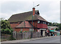
Ransom Road: The Canon Lewis Memorial Hall
According to the Draft List of Local Heritage Assets of the City of Nottingham, this building, designed in 1907 by Calvert & Gleave, is "plainer [and] less florid than the architects' drawing". It was owned by the 6th Nottingham Company of the Boys' Brigade from 1964-98. For details and the architects' drawing, see http://stannswellroad.weebly.com/the-boys-brigade.html .
Image: © John Sutton
Taken: 15 Jun 2014
0.15 miles
9
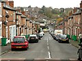
Looking down Cromer Road, St Ann's
The small group of terrace streets including Cromer Road where not included in the wholesale replacement of Victorian terraces in the St Ann's area in the 1960s and 70s. These terraces are slightly later and were presumably assessed as being in adequate condition to be retained.
Image: © Alan Murray-Rust
Taken: 27 Nov 2022
0.16 miles
10
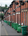
Ransom Road: wheelie bins and satellite dishes
A typical Nottingham terrace, at the St Ann's Well Road end of Ransom Road.
Image: © John Sutton
Taken: 15 Jun 2014
0.16 miles