IMAGES TAKEN NEAR TO
Hazelbank Avenue, NOTTINGHAM, NG3 3EY
Introduction
This page details the photographs taken nearby to Hazelbank Avenue, NG3 3EY by members of the Geograph project.
The Geograph project started in 2005 with the aim of publishing, organising and preserving representative images for every square kilometre of Great Britain, Ireland and the Isle of Man.

There are currently over 7.5m images from over14,400 individuals and you can help contribute to the project by visiting https://www.geograph.org.uk
Image Map
Images are licensed for reuse under creativecommons.org/licenses/by-sa/2.0
Notes
- Clicking on the map will re-center to the selected point.
- The higher the marker number, the further away the image location is from the centre of the postcode.
Image Listing (34 Images Found)
Images are licensed for reuse under creativecommons.org/licenses/by-sa/2.0
Image
Details
Distance
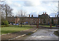
1
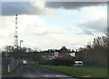
Ransom Drive
The approach road to the former Coppice Hospital (now Hine Hall), which is silhouetted. Also visible is the Springwood day Centre.
Image: © Alan Murray-Rust
Taken: 8 Mar 2009
0.06 miles
2
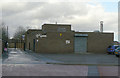
Springwood Day Centre
Providing community facilities for people with various disabilities.
Image: © Alan Murray-Rust
Taken: 8 Mar 2009
0.08 miles
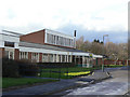
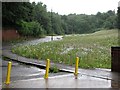
3
Mapperley Sports Village
A slightly pretentious name for what is effectively a multi-sports hall. Attached to Elliot Durham School.
Image: © Alan Murray-Rust
Taken: 8 Mar 2009
0.10 miles
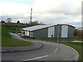
4
Mapperley Sports Village
A mixture of mixed sports indoor and outdoor facilities.
Image: © Alan Murray-Rust
Taken: 27 Nov 2022
0.10 miles
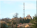
5
Hine Hall
Built in 1857-9 as the County Lunatic Asylum, later known as Coppice Hospital. It is now converted into apartments. The name is in honour of the building's architect, T.C.Hine.
Image: © Alan Murray-Rust
Taken: 8 Mar 2009
0.11 miles
6
St Ann's Well: once the Nottingham Suburban Railway
Looking towards what was from 1889-1951 the north end of St Ann's Well station and yard. Beyond the trees straight ahead the line passed under Bridge No 10 and curved gently left towards the south portal of Sherwood Tunnel, about half a mile to the north. See Image] for more history.
Image: © John Sutton
Taken: 20 Jul 2012
0.12 miles
7
Former Coppice Hospital
Standing on a prominent spur above St Ann's, Coppice Hospital was built in the 1870s as the County Lunatic Asylym. It has now been converted into apartments and renamed Hine Hall to commemorate its architect.
Image: © Alan Murray-Rust
Taken: 8 Mar 2009
0.14 miles
8
Ransom Drive
Recent housing (2017-18) on the site of the former Springwood Centre https://www.geograph.org.uk/photo/1197640 https://www.geograph.org.uk/photo/1197610 .
Image: © Alan Murray-Rust
Taken: 27 Nov 2022
0.14 miles
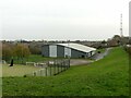
9
Elliot Durham baths
Part of the Elliot Durham School Campus. The roadway to the left is the main access to the school.
Image: © Alan Murray-Rust
Taken: 8 Mar 2009
0.14 miles
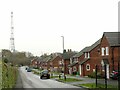
10
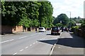
The Wells Road
Looking downhill towards the city centre.
Image: © David Lally
Taken: 5 Jul 2016
0.16 miles