IMAGES TAKEN NEAR TO
Edginton Street, NOTTINGHAM, NG3 3EB
Introduction
This page details the photographs taken nearby to Edginton Street, NG3 3EB by members of the Geograph project.
The Geograph project started in 2005 with the aim of publishing, organising and preserving representative images for every square kilometre of Great Britain, Ireland and the Isle of Man.

There are currently over 7.5m images from over14,400 individuals and you can help contribute to the project by visiting https://www.geograph.org.uk
Image Map
Images are licensed for reuse under creativecommons.org/licenses/by-sa/2.0
Notes
- Clicking on the map will re-center to the selected point.
- The higher the marker number, the further away the image location is from the centre of the postcode.
Image Listing (21 Images Found)
Images are licensed for reuse under creativecommons.org/licenses/by-sa/2.0
Image
Details
Distance
1
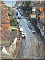
Donkey Hill
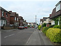
Officially St bartholomew's Road, it's always known locally by its nickname, although where this originates I do not know. The gradient is probably about 1 in 7.
Image: © Alan Murray-Rust
Taken: 8 Mar 2009
0.08 miles
2
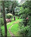
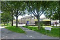
The Visitor
Urban Garden, Thorney Hill, Nottingham
Image: © Sarah Walton
Taken: 24 Jul 2017
0.14 miles
4
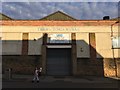
The V ctoria Works
The Wells Road, St Ann's
Image: © David Lally
Taken: 12 Aug 2017
0.16 miles
6
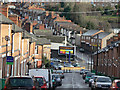
Cromer Road
Terraced housing towards the east end of St Ann's
Image: © Alan Murray-Rust
Taken: 8 Mar 2009
0.18 miles
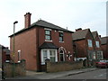
9
The former Ransom Road Police Station
Recreating this 'First' for the square https://www.geograph.org.uk/photo/43311 .
The station had closed by 2008 and was converted to two small housing units around 2010. The bottom of Cromer Road had also been stopped up for motor traffic by 2008.
Image: © Alan Murray-Rust
Taken: 27 Nov 2022
0.20 miles
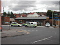
10
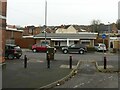
Heron Foods shop
Formerly "The Westminster" public house.
Image: © David Lally
Taken: 5 Jul 2016
0.20 miles