IMAGES TAKEN NEAR TO
Landmere Gardens, NOTTINGHAM, NG3 3BG
Introduction
This page details the photographs taken nearby to Landmere Gardens, NG3 3BG by members of the Geograph project.
The Geograph project started in 2005 with the aim of publishing, organising and preserving representative images for every square kilometre of Great Britain, Ireland and the Isle of Man.

There are currently over 7.5m images from over14,400 individuals and you can help contribute to the project by visiting https://www.geograph.org.uk
Image Map
Images are licensed for reuse under creativecommons.org/licenses/by-sa/2.0
Notes
- Clicking on the map will re-center to the selected point.
- The higher the marker number, the further away the image location is from the centre of the postcode.
Image Listing (36 Images Found)
Images are licensed for reuse under creativecommons.org/licenses/by-sa/2.0
Image
Details
Distance
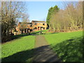
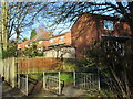
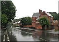
2

The Wells Road houses at Landmere Gardens junction
Image: © Roger Templeman
Taken: 10 May 2022
0.07 miles
4
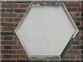
Plaque to Henrietta Carey
Almost unreadable plaque attached to frontage of 455/457 The Wells Road close to the former site of St Ann's Well Station on the Nottingham Suburban Railway.
Image: © El Loco
Taken: 7 Apr 2021
0.09 miles
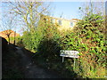
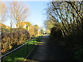
5
Footpath leading to Mickleborough Avenue
Image: © Jonathan Thacker
Taken: 15 Jan 2016
0.09 miles
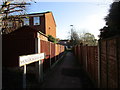
6
The Wells Road - end of footpath leading to Porchester Road
Image: © Jonathan Thacker
Taken: 15 Jan 2016
0.09 miles
7
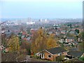
View from Porchester Road Towards the City
The tower blocks around the Victoria Centre dominate the view. To the left, nicely framed by two cranes the dome of the Council House can be seen.
Image: © Mick Garratt
Taken: 3 Dec 2005
0.10 miles
8
Path approaching Woodhedge Drive
The path continues up to Porchester Road.
Image: © Jonathan Thacker
Taken: 15 Jan 2016
0.10 miles
9
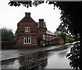
Former Station Master's House on The Wells Road
The house ahead was built for the opening of the Nottingham Suburban Railway in 1889. For more about the house and the NSR, see Image The road to the left, leading to houses built on the former railway goods yard, is Dooland Drive - named after Bruce Dooland, the classy Australian leg-spinner who played for Nottinghamshire in the 1950s and was my first cricket hero. This was a horribly wet and gloomy morning, even by the standards of the summer of 2012.
Image: © John Sutton
Taken: 20 Jul 2012
0.10 miles
10
Once St Ann's Well Station Master's House
The Victorian house on the right was originally the home of the station master at St Ann's Well on the Nottingham Suburban Railway (1889-1951). The station, of which there is now no trace, was largely on a wide embankment behind the council houses further down the hill, and the railway crossed The Wells Road a little way to the south on a high lattice girder bridge. The NSR (operated by the Great Northern) lost its passenger service in 1916 in face of competition from the city's trams, but the goods yard continued to supply coal merchants and serve the Somnus bed company until closure. The NSR was promoted by the owners of the Nottingham Patent Brick Company and the house is built of red bricks and terra cotta tiles from its brickyards at Thorneywood and Mapperley. (A more celebrated station built of NPBC bricks is St Pancras.) This was one of the more relentlessly rainy mornings of the wet summer of 2012.
Image: © John Sutton
Taken: 20 Jul 2012
0.10 miles