IMAGES TAKEN NEAR TO
Stainby Road, GRANTHAM, NG33 5RY
Introduction
This page details the photographs taken nearby to Stainby Road, NG33 5RY by members of the Geograph project.
The Geograph project started in 2005 with the aim of publishing, organising and preserving representative images for every square kilometre of Great Britain, Ireland and the Isle of Man.

There are currently over 7.5m images from over14,400 individuals and you can help contribute to the project by visiting https://www.geograph.org.uk
Image Map
Images are licensed for reuse under creativecommons.org/licenses/by-sa/2.0
Notes
- Clicking on the map will re-center to the selected point.
- The higher the marker number, the further away the image location is from the centre of the postcode.
Image Listing (165 Images Found)
Images are licensed for reuse under creativecommons.org/licenses/by-sa/2.0
Image
Details
Distance
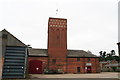
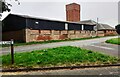
1
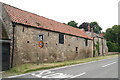
Farm buildings and water tower, Buckminster
The water tower is a convenient site for positioning telecommunications equipment.
Image: © Jonathan Thacker
Taken: 30 Dec 2019
0.03 miles
3
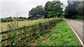
Field and copse on south side of Stainby Road
Ordnance Survey documents indicate that a benchmark levelled at 156.951m above Newlyn Datum was verified in 1968 on a farm building at this location
Image: © Roger Templeman
Taken: 28 Jun 2023
0.05 miles
4

Stainby Road (B676), Buckminster
Looking eastward.
Image: © Peter Wood
Taken: 11 Oct 2021
0.05 miles
5
Buckminster Water Tower and barns
Converted to industrial use.
Image: © Chris
Taken: 20 Jul 2013
0.06 miles
6
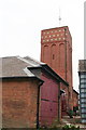
Buckminster Water Tower and barns
The yard looks to have been the estate's maintenance facility, but is now converted to business use.
Image: © Chris
Taken: 20 Jul 2013
0.06 miles
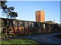
7
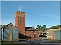
Water tower at Manor Farm, Buckminster
Erected as part of the farm complex around 1900, it was also an Ordnance Survey triangulation point with a bolt on top of the tower.
Image: © Alan Murray-Rust
Taken: 13 Nov 2016
0.06 miles
8
Buildings at Manor Farm, Buckminster
This is essentially the home farm of Buckminster Hall, the buildings dating from around 1900.
Image: © Alan Murray-Rust
Taken: 13 Nov 2016
0.06 miles
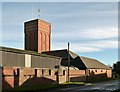
9
Farm buildings and water tower on north side of Stainby Road (B676)
Ordnance Survey documents indicate that a bolt on the roof of the water tower is a triangulation station whose location (SK 88170 22951) was computed in 1938. Communications equipment is visible on the roof.
Image: © Roger Templeman
Taken: 28 Jun 2023
0.06 miles