IMAGES TAKEN NEAR TO
Main Street, GRANTHAM, NG33 5RQ
Introduction
This page details the photographs taken nearby to Main Street, NG33 5RQ by members of the Geograph project.
The Geograph project started in 2005 with the aim of publishing, organising and preserving representative images for every square kilometre of Great Britain, Ireland and the Isle of Man.

There are currently over 7.5m images from over14,400 individuals and you can help contribute to the project by visiting https://www.geograph.org.uk
Image Map
Images are licensed for reuse under creativecommons.org/licenses/by-sa/2.0
Notes
- Clicking on the map will re-center to the selected point.
- The higher the marker number, the further away the image location is from the centre of the postcode.
Image Listing (53 Images Found)
Images are licensed for reuse under creativecommons.org/licenses/by-sa/2.0
Image
Details
Distance
1
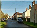
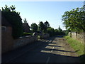
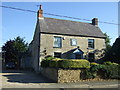
Main Street, Sewstern
Looking east.
There is a bench mark http://www.geograph.org.uk/photo/5196684 on the gable end of the house on the right.
Image: © Alan Murray-Rust
Taken: 13 Nov 2016
0.01 miles
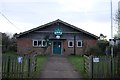
3

Defibrillator at the village hall
An AED in the entrance of the village hall
Image: © Bob Harvey
Taken: 14 Dec 2019
0.02 miles
5
Bench mark, 79 Main Street, Sewstern
See http://www.geograph.org.uk/photo/5196686 for location.
Image: © Alan Murray-Rust
Taken: 13 Nov 2016
0.03 miles
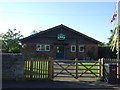
6
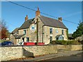
The Blue Dog, Sewstern
Late 18th century farmhouse, later converted to a public house, which it still is. Note the AA village sign http://www.geograph.org.uk/photo/5196693 (below the inn sign) on the end wall. Listed Grade II.
Image: © Alan Murray-Rust
Taken: 13 Nov 2016
0.03 miles
9
AA village sign, Sewstern
See http://www.geograph.org.uk/photo/5196688 for location.
Image: © Alan Murray-Rust
Taken: 13 Nov 2016
0.04 miles
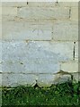
10
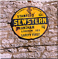
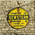
Old circular AA Sign on Main Street, Sewstern
Old AA Sign on the west facing gable end of the Blue Dog PH on Main Street, Sewstern, 10 miles south of Grantham. Buckminster parish.
This is the circular, village name on black band, no Motor Union symbol or name type, dating from 1923, and showing distances Stamford 13½ Grantham 10 London 103.
There were five series of AA signs, mostly dating from 1923 and made by Francis & Co / Franco in Deptford, London. The village name and distance to London were usually displayed.
See also https://www.geograph.org.uk/photo/5196693 and https://www.geograph.org.uk/photo/5914109.
Milestone Society National ID: LE-SEWST
Image: © Milestone Society
Taken: Unknown
0.04 miles