IMAGES TAKEN NEAR TO
Moor Lane, GRANTHAM, NG33 5PP
Introduction
This page details the photographs taken nearby to Moor Lane, NG33 5PP by members of the Geograph project.
The Geograph project started in 2005 with the aim of publishing, organising and preserving representative images for every square kilometre of Great Britain, Ireland and the Isle of Man.

There are currently over 7.5m images from over14,400 individuals and you can help contribute to the project by visiting https://www.geograph.org.uk
Image Map
Images are licensed for reuse under creativecommons.org/licenses/by-sa/2.0
Notes
- Clicking on the map will re-center to the selected point.
- The higher the marker number, the further away the image location is from the centre of the postcode.
Image Listing (8 Images Found)
Images are licensed for reuse under creativecommons.org/licenses/by-sa/2.0
Image
Details
Distance
2
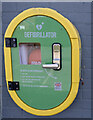
Defibrillator box
On the outside of the shop seen in Image
Image: © Bob Harvey
Taken: 12 Mar 2023
0.11 miles
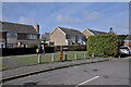
3
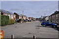
Great Close
Estate road in South Witham.
Image: © Bob Harvey
Taken: 12 Mar 2023
0.11 miles
4
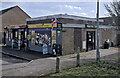
Village centre
Shop and chippy in the centre of South Witham.
This estate was built for staff at the local RAF base
Image: © Bob Harvey
Taken: 12 Mar 2023
0.11 miles
5

Working on the roof
A scaffold shelter has been erected around this house while renovation proceeds.
Image: © Bob Harvey
Taken: 12 Mar 2023
0.18 miles
6
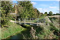
River Witham entering South Witham
The footpath across the bridge connects the newer housing area on the left to the older part of the village ahead
Image: © Tim Heaton
Taken: 24 Oct 2013
0.21 miles
7

Hedge enclosed Moor Lane near to South Witham
Looking south-westward.
Image: © Peter Wood
Taken: 11 Oct 2021
0.23 miles
8
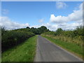
Moor Lane
This is just beyond the edge of South Witham on the quieter of the two roads leading to the ancient road known as The Drift.
Image: © Marathon
Taken: 12 Aug 2017
0.23 miles