IMAGES TAKEN NEAR TO
North Road, GRANTHAM, NG33 5PA
Introduction
This page details the photographs taken nearby to North Road, NG33 5PA by members of the Geograph project.
The Geograph project started in 2005 with the aim of publishing, organising and preserving representative images for every square kilometre of Great Britain, Ireland and the Isle of Man.

There are currently over 7.5m images from over14,400 individuals and you can help contribute to the project by visiting https://www.geograph.org.uk
Image Map
Images are licensed for reuse under creativecommons.org/licenses/by-sa/2.0
Notes
- Clicking on the map will re-center to the selected point.
- The higher the marker number, the further away the image location is from the centre of the postcode.
Image Listing (5 Images Found)
Images are licensed for reuse under creativecommons.org/licenses/by-sa/2.0
Image
Details
Distance
1
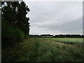
Barley field and Lodge Farm
The footpath which used to cut across the barley field now passes to the west of Ironstone Plantation and to the east of Bailey's Plantation.
Image: © Jonathan Thacker
Taken: 4 Jul 2020
0.03 miles
4
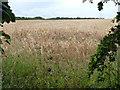
Field of barley near Lodge Farm, Colsterworth
Image: © Richard Humphrey
Taken: 12 Jul 2015
0.23 miles
5
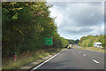
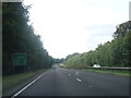
A1 northbound
The partly obscured distance sign advises Grantham 6, Newark 20 and Doncaster 58. All these places are skirted by the modern A1. The small distance marker post shows 66 6.
Image: © Robin Webster
Taken: 7 Oct 2011
0.23 miles