IMAGES TAKEN NEAR TO
High Street, GRANTHAM, NG33 5NF
Introduction
This page details the photographs taken nearby to High Street, NG33 5NF by members of the Geograph project.
The Geograph project started in 2005 with the aim of publishing, organising and preserving representative images for every square kilometre of Great Britain, Ireland and the Isle of Man.

There are currently over 7.5m images from over14,400 individuals and you can help contribute to the project by visiting https://www.geograph.org.uk
Image Map
Images are licensed for reuse under creativecommons.org/licenses/by-sa/2.0
Notes
- Clicking on the map will re-center to the selected point.
- The higher the marker number, the further away the image location is from the centre of the postcode.
Image Listing (125 Images Found)
Images are licensed for reuse under creativecommons.org/licenses/by-sa/2.0
Image
Details
Distance
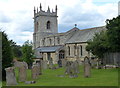
1
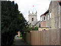
Colsterworth: St John the Baptist
Seen from the High Street.
Image: © John Sutton
Taken: 27 Aug 2009
0.00 miles
2
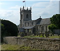
Church of St John the Baptist in Colsterworth
Image: © Mat Fascione
Taken: 21 Jun 2014
0.00 miles
3
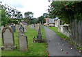
Churchyard of St John the Baptist in Colsterworth
Image: © Mat Fascione
Taken: 18 Aug 2019
0.01 miles
5
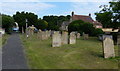
Gravestones at St John the Baptist church
Image: © Mat Fascione
Taken: 21 Jun 2014
0.01 miles
6
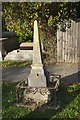
Obelisk grave marker
I could not find any name or dedication
Image: © Bob Harvey
Taken: 19 Oct 2018
0.02 miles
8

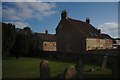
Holly in the churchyard
The church of St John the Baptist.
An impressive Holly tree rather than the more traditional Yew tree.
Image: © Anthony Vosper
Taken: 7 Nov 2016
0.02 miles
9
Church of St John the Baptist in Colsterworth
Image: © Mat Fascione
Taken: 18 Aug 2019
0.02 miles
10
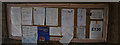
The Church of John the Baptist: Church notices
Notices in the porch
Image: © Bob Harvey
Taken: 19 Oct 2018
0.02 miles