IMAGES TAKEN NEAR TO
Lobthorpe, GRANTHAM, NG33 5LS
Introduction
This page details the photographs taken nearby to NG33 5LS by members of the Geograph project.
The Geograph project started in 2005 with the aim of publishing, organising and preserving representative images for every square kilometre of Great Britain, Ireland and the Isle of Man.

There are currently over 7.5m images from over14,400 individuals and you can help contribute to the project by visiting https://www.geograph.org.uk
Image Map
Images are licensed for reuse under creativecommons.org/licenses/by-sa/2.0
Notes
- Clicking on the map will re-center to the selected point.
- The higher the marker number, the further away the image location is from the centre of the postcode.
Image Listing (6 Images Found)
Images are licensed for reuse under creativecommons.org/licenses/by-sa/2.0
Image
Details
Distance
1
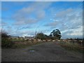
Gated track from Woolley's Lane near the A1
Image: © Steve Fareham
Taken: 25 Oct 2013
0.11 miles
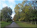
2
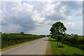
Entrance to Lobthorpe
A hamlet with few dwellings
Image: © Tim Heaton
Taken: 19 Jun 2017
0.12 miles
3
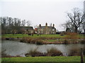
Hall Farm, Lobthorpe
Old moat in foreground
Image: © Tim Heaton
Taken: 12 Feb 2006
0.16 miles
4
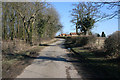
Woolley's Lane and Hall Farm, Lobthorpe
The farm house is to the south of Woolley's Lane and the extensive farm buildings are to the north just round the bend in the road. There is the site of a deserted Medieval village at Lobthorpe although all there is now are a few cottages and this farm.
Image: © Kate Jewell
Taken: 7 Mar 2010
0.16 miles
6
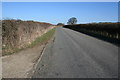
Woolley's Lane
Looking towards Lobthorpe.
Image: © Kate Jewell
Taken: 7 Mar 2010
0.20 miles