IMAGES TAKEN NEAR TO
Woodyard Close, NG33 5LD
Introduction
This page details the photographs taken nearby to Woodyard Close, NG33 5LD by members of the Geograph project.
The Geograph project started in 2005 with the aim of publishing, organising and preserving representative images for every square kilometre of Great Britain, Ireland and the Isle of Man.

There are currently over 7.5m images from over14,400 individuals and you can help contribute to the project by visiting https://www.geograph.org.uk
Image Map
Images are licensed for reuse under creativecommons.org/licenses/by-sa/2.0
Notes
- Clicking on the map will re-center to the selected point.
- The higher the marker number, the further away the image location is from the centre of the postcode.
Image Listing (45 Images Found)
Images are licensed for reuse under creativecommons.org/licenses/by-sa/2.0
Image
Details
Distance
1

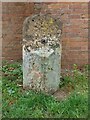
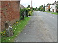
Old Milestone by the B6403, Stamford Road, Colsterworth
Carved stone post by the B6403 (was A1), in parish of COLSTERWORTH (SOUTH KESTEVEN District), Stamford Road, near No.17, on the verge, back to red brick outbuilding, on West side of road. Erected by the Grantham South District turnpike trust in the 19th century.
Inscription once read:-
: (Grantham / 8) : : (Stamford / 13) :
Milestone Society National ID: LI_LYA102.
Image: © Hilary Jones
Taken: 9 Sep 2024
0.07 miles
2
Old Milestone by the B6403, Stamford Road, Colsterworth
Carved stone post by the B6403 (was A1), in parish of COLSTERWORTH (SOUTH KESTEVEN District), Stamford Road, near No.17, on the verge, back to red brick outbuilding, on West side of road. Erected by the Grantham South District turnpike trust in the 19th century.
Inscription once read:-
: (Grantham / 8) : : (Stamford / 13) :
Milestone Society National ID: LI_LYA102.
Image: © Hilary Jones
Taken: 9 Sep 2024
0.07 miles
3
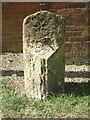
Old Milestone by the B6403, Stamford Road, Colsterworth
Carved stone post by the B6403 (was A1), in parish of COLSTERWORTH (SOUTH KESTEVEN District), Stamford Road, near No.17, on the verge, back to red brick outbuilding, on West side of road. Erected by the Grantham South District turnpike trust in the 19th century.
Inscription once read:-
: (Grantham / 8) : : (Stamford / 13) :
Milestone Society National ID: LI_LYA102.
Image: © MW Hallett
Taken: 18 Apr 2003
0.07 miles
5
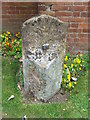
Old Milestone
Old milestone at Colsterworth, Lincolnshire on what was the Great North Road, later to become the A1' for overall view see http://www.geograph.org.uk/photo/3652628
Image: © Keith Evans
Taken: 9 Sep 2013
0.07 miles
6
Old Milestone
Old milestone at Colsterworth, Lincolnshire on what was the Great North Road later to become the A.1 for close up view see http://www.geograph.org.uk/photo/3652620
Image: © Keith Evans
Taken: 9 Sep 2013
0.07 miles
8
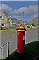
Decorated Pillar Box
Crowned, as it were, with a crocheted cap for the Jubilee.
See also Image
Image: © Bob Harvey
Taken: 30 Apr 2022
0.08 miles
9

Crowned again
Letter boxes already bear the crown, for they were erected when the Royal Mail was truly Royal. To celebrate the Platinum Jubilee this one has been capped with another crown, modelled on the St Edward's Crown used in the coronation in 1953.
Image: © Bob Harvey
Taken: 30 Apr 2022
0.08 miles
10
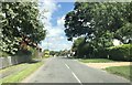
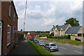
Above the road
The gradient of the hill through Colsterworth was eased in the 1930s, leaving the pavement here well above the road surface.
Image: © Bob Harvey
Taken: 3 Dec 2021
0.08 miles