IMAGES TAKEN NEAR TO
Bourne Road, GRANTHAM, NG33 5JP
Introduction
This page details the photographs taken nearby to Bourne Road, NG33 5JP by members of the Geograph project.
The Geograph project started in 2005 with the aim of publishing, organising and preserving representative images for every square kilometre of Great Britain, Ireland and the Isle of Man.

There are currently over 7.5m images from over14,400 individuals and you can help contribute to the project by visiting https://www.geograph.org.uk
Image Map
Images are licensed for reuse under creativecommons.org/licenses/by-sa/2.0
Notes
- Clicking on the map will re-center to the selected point.
- The higher the marker number, the further away the image location is from the centre of the postcode.
Image Listing (5 Images Found)
Images are licensed for reuse under creativecommons.org/licenses/by-sa/2.0
Image
Details
Distance
1
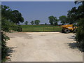
Field and Dumper
This entrance leads to Pasture Lodge. It has clearly had a recent makeover including some new fencing for the pasture.
Image: © Michael Patterson
Taken: 9 Jun 2006
0.11 miles
2
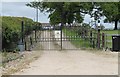
Gates at entrance to Pasture Lodge
Plus guard dogs apparently.
Image: © J.Hannan-Briggs
Taken: 9 Jun 2013
0.12 miles
5
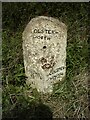
Old Milestone, on the A151, Bourne Road, near Twyford Wood
20m W of Colsterworth Pasture Lodge. Located on the North side of road, on the verge. Concrete post, Bourn iron casting design, erected by Lincoln Heath to Peterborough - West District turnpike trust, 19th century.
Inscription reads: // BOURN / 11 //COLSTER / WORTH // ~OLSTER / WORTH
Grade II listed by Historic England. see https://historicengland.org.uk/listing/the-list/list-entry/1360346
Milestone Society National ID: LI_BNCW11
Image: © Milestone Society
Taken: Unknown
0.14 miles