IMAGES TAKEN NEAR TO
Turnor Close, GRANTHAM, NG33 5JH
Introduction
This page details the photographs taken nearby to Turnor Close, NG33 5JH by members of the Geograph project.
The Geograph project started in 2005 with the aim of publishing, organising and preserving representative images for every square kilometre of Great Britain, Ireland and the Isle of Man.

There are currently over 7.5m images from over14,400 individuals and you can help contribute to the project by visiting https://www.geograph.org.uk
Image Map
Images are licensed for reuse under creativecommons.org/licenses/by-sa/2.0
Notes
- Clicking on the map will re-center to the selected point.
- The higher the marker number, the further away the image location is from the centre of the postcode.
Image Listing (51 Images Found)
Images are licensed for reuse under creativecommons.org/licenses/by-sa/2.0
Image
Details
Distance
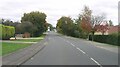
2
Houses on the Bourne Road Estate
Seen from the Bourne Road.
Image: © Christine Johnstone
Taken: 18 Mar 2011
0.09 miles
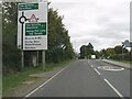
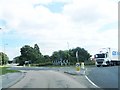
7
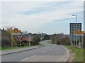
Colsterworth welcomes careful drivers
The B676 entering the village from the east.
Image: © Christine Johnstone
Taken: 18 Mar 2011
0.16 miles
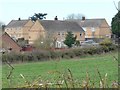
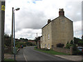
8

Old house in Back Lane, Colsterworth
Back Lane is a typical feature of a village where a back lane was created to run parallel to the main road through the village. At Colsterworth this main road (High Street) used to be the Great North Road until 1926. Now Back Lane is actually wider than High Street. This fine house is clearly earlier than 1851 which was the date when the Window Tax was repealed.
Image: © Marathon
Taken: 7 Sep 2019
0.16 miles
9

Colsterworth Methodist Church
Colsterworth Methodist Church is on the corner of Back Lane and The Ropewalk. The church dates from the 1830s.
Image: © Marathon
Taken: 7 Sep 2019
0.16 miles
10

Back Lane, Colsterworth
Back Lane is a typical feature of a village where a back lane was created to run parallel to the main road through the village. At Colsterworth this main road (High Street) used to be the Great North Road until 1926. Now Back Lane is actually wider than High Street. This fine house is clearly earlier than 1851 which was the date when the Window Tax was repealed.
Image: © Marathon
Taken: 7 Sep 2019
0.17 miles