IMAGES TAKEN NEAR TO
Skillington Road, GRANTHAM, NG33 5HL
Introduction
This page details the photographs taken nearby to Skillington Road, NG33 5HL by members of the Geograph project.
The Geograph project started in 2005 with the aim of publishing, organising and preserving representative images for every square kilometre of Great Britain, Ireland and the Isle of Man.

There are currently over 7.5m images from over14,400 individuals and you can help contribute to the project by visiting https://www.geograph.org.uk
Image Map
Images are licensed for reuse under creativecommons.org/licenses/by-sa/2.0
Notes
- Clicking on the map will re-center to the selected point.
- The higher the marker number, the further away the image location is from the centre of the postcode.
Image Listing (8 Images Found)
Images are licensed for reuse under creativecommons.org/licenses/by-sa/2.0
Image
Details
Distance
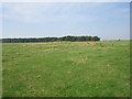
1
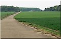
The south eastern edge of Saltby Airfield
Saltby Airfield was a World War II airfield constructed in 1942, now used by Buckminster Gliding Club. http://en.wikipedia.org/wiki/RAF_Saltby
Image: © Mat Fascione
Taken: 10 May 2008
0.12 miles

3

Farmland, Saltby Airfield
This is Saltby Heath Farm, adjacent to Saltby Airfield.
Image: © Kate Jewell
Taken: 23 Oct 2005
0.18 miles
4
Viking Way along The Drift WNW of Skillington
Image: © Colin Park
Taken: 18 Jul 2014
0.22 miles
5
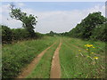
Sewstern Lane - 20 (The Drift)
Some parts of this long 'green lane' have been rendered impassable by 'off-roaders'.
Image: © Tim Heaton
Taken: 27 May 2016
0.22 miles
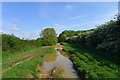
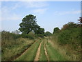
6
The drift approaching Hangar Plantation
Motorised vehicles have caused some quite deep ruts.
Image: © Jonathan Thacker
Taken: 14 Sep 2016
0.23 miles
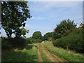
7
The drift near Saltby Heath Farm
Although motorised vehicles are not encouraged here some are quite clearly used. Sometimes ruts can be quite deep but not here.
Image: © Jonathan Thacker
Taken: 14 Sep 2016
0.24 miles
8
View towards Gallops Plantation
This land once formed part of RAF Saltby.
Image: © Jonathan Thacker
Taken: 14 Sep 2016
0.25 miles