IMAGES TAKEN NEAR TO
Skillington Road, GRANTHAM, NG33 5HJ
Introduction
This page details the photographs taken nearby to Skillington Road, NG33 5HJ by members of the Geograph project.
The Geograph project started in 2005 with the aim of publishing, organising and preserving representative images for every square kilometre of Great Britain, Ireland and the Isle of Man.

There are currently over 7.5m images from over14,400 individuals and you can help contribute to the project by visiting https://www.geograph.org.uk
Image Map
Images are licensed for reuse under creativecommons.org/licenses/by-sa/2.0
Notes
- Clicking on the map will re-center to the selected point.
- The higher the marker number, the further away the image location is from the centre of the postcode.
Image Listing (4 Images Found)
Images are licensed for reuse under creativecommons.org/licenses/by-sa/2.0
Image
Details
Distance
1
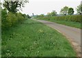
The road to Sproxton
In northeast Leicestershire.
Image: © Mat Fascione
Taken: 10 May 2008
0.21 miles
2
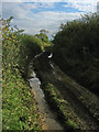
Sewstern Drift, near Skillington
Looking SE from the Skillington/Sproxton Road. This section of the Sewstern Drift is very eroded and mashed up by over-land trial bikes. Not very pleasant for walking.
Image: © Kate Jewell
Taken: 23 Oct 2005
0.23 miles
3
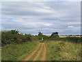
The Viking Way near Skillington
The ruts in the track just starting to become deep enough to make cycling difficult
Image: © Tim Heaton
Taken: 2 Sep 2007
0.24 miles
4
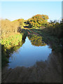
Water on the Drift
The rutted nature of the track here allows water to collect, and despite minimal rain for a few weeks the puddles remain big enough that they are difficult to walk around.
Image: © Andy Stephenson
Taken: 14 Oct 2015
0.25 miles