IMAGES TAKEN NEAR TO
Brunel Avenue, GRANTHAM, NG33 5GA
Introduction
This page details the photographs taken nearby to Brunel Avenue, NG33 5GA by members of the Geograph project.
The Geograph project started in 2005 with the aim of publishing, organising and preserving representative images for every square kilometre of Great Britain, Ireland and the Isle of Man.

There are currently over 7.5m images from over14,400 individuals and you can help contribute to the project by visiting https://www.geograph.org.uk
Image Map
Images are licensed for reuse under creativecommons.org/licenses/by-sa/2.0
Notes
- Clicking on the map will re-center to the selected point.
- The higher the marker number, the further away the image location is from the centre of the postcode.
Image Listing (200 Images Found)
Images are licensed for reuse under creativecommons.org/licenses/by-sa/2.0
Image
Details
Distance
1
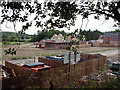
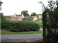
Colsterworth: new housing development
These houses are being built on what was from 1920-73 the site of the extensive engine sheds, workshops and offices of the Colsterworth Quarries railway system.
Image: © John Sutton
Taken: 27 Aug 2009
0.05 miles
2
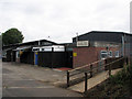
Colsterworth: Sir Isaac Newton Memorial Hall
Image: © John Sutton
Taken: 27 Aug 2009
0.10 miles
3
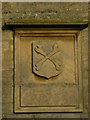
Woolsthorpe Manor coat of arms
The Newton family’s crossed bones coat of arms, placed above the front door of the manor house by Edmund Turner in 1798. Woolsthorpe Manor was the birthplace of Isaac Newton
Image: © Robin Jones
Taken: 1 Mar 2008
0.11 miles
4
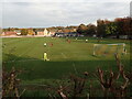
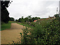
Football at Colsterworth
This is the view from Old Post Lane on a Saturday afternoon.
Image: © Marathon
Taken: 29 Oct 2022
0.12 miles
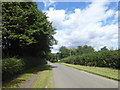
6
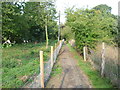
Footpath to Colsterworth
This footpath leads from Old Post Lane here, across the infant River Witham to Colsterworth Church on the far side.
Image: © Marathon
Taken: 22 Aug 2015
0.14 miles
7
Woolsthorpe Manor Car Park - former ironstone quarry
The roof and gables of Newton's birthplace are glimpsed to the right. The visitor car park is on the restored site of the entrance to the huge Colsterworth No 2 Extension ironstone quarry (1935-69), one of the quarries which once encircled Woolsthorpe. No 2 Extension quarry once covered most of gridsquare SK9123. The quarry railway once crossed Old Post Lane on a level crossing immediately behind where I stood to take this picture. The smaller No 2 quarry (1927-32) was to the east of the lane, as were the engine sheds and workshops (a new housing development is currently being built on their site). See other photos nearby for more on the Colsterworth quarries and railways and the High Dyke Branch.
Image: © John Sutton
Taken: 27 Aug 2009
0.14 miles
8
Woolsthorpe: site of quarry railway level crossing
The Colsterworth Quarries railway crossed Old Post Lane here until quarrying ceased in 1973. The crossing gates were apparently of mainline standard; the hedge marks their position. Newton's birthplace, Woolsthorpe Manor, is in the background. See other photos nearby for more on the quarries and railways in the area.
Image: © John Sutton
Taken: 27 Aug 2009
0.14 miles
9
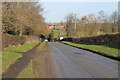
Old Post Lane, Colsterworth
This is Old Post Lane, looking in the direction of Woolsthorpe. The entrance to the cemetery for Woolsthorpe and Colsterworth is on the left.
Image: © Marathon
Taken: 12 Aug 2017
0.15 miles
10
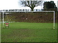
Quiet times at Colsterworth Football Club
It seems that on occasions the goalkeeper is less than busy and has time for a sit down.
Image: © Kenneth Yarham
Taken: 31 Dec 2005
0.15 miles