IMAGES TAKEN NEAR TO
Stoke Rochford, GRANTHAM, NG33 5ET
Introduction
This page details the photographs taken nearby to NG33 5ET by members of the Geograph project.
The Geograph project started in 2005 with the aim of publishing, organising and preserving representative images for every square kilometre of Great Britain, Ireland and the Isle of Man.

There are currently over 7.5m images from over14,400 individuals and you can help contribute to the project by visiting https://www.geograph.org.uk
Image Map
Images are licensed for reuse under creativecommons.org/licenses/by-sa/2.0
Notes
- Clicking on the map will re-center to the selected point.
- The higher the marker number, the further away the image location is from the centre of the postcode.
Image Listing (4 Images Found)
Images are licensed for reuse under creativecommons.org/licenses/by-sa/2.0
Image
Details
Distance
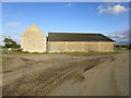
1

Heslin's Barn Farm
On the bridleway track heading towards Grantham Road, north of Skillington
Image: © Tim Heaton
Taken: 20 Aug 2017
0.02 miles
2
Farm buildings, Heslin's Barn Farm
Image: © Jonathan Thacker
Taken: 22 Oct 2019
0.02 miles
3
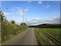
Roadway from Heslin's Barn Farm
A bridleway.
Image: © Jonathan Thacker
Taken: 22 Oct 2019
0.13 miles
4
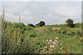
Overgrown Footpath near Herring's Lodge Farm
Image: © J.Hannan-Briggs
Taken: 12 Aug 2012
0.23 miles