IMAGES TAKEN NEAR TO
Stoke Rochford, GRANTHAM, NG33 5EB
Introduction
This page details the photographs taken nearby to NG33 5EB by members of the Geograph project.
The Geograph project started in 2005 with the aim of publishing, organising and preserving representative images for every square kilometre of Great Britain, Ireland and the Isle of Man.

There are currently over 7.5m images from over14,400 individuals and you can help contribute to the project by visiting https://www.geograph.org.uk
Image Map
Images are licensed for reuse under creativecommons.org/licenses/by-sa/2.0
Notes
- Clicking on the map will re-center to the selected point.
- The higher the marker number, the further away the image location is from the centre of the postcode.
Image Listing (85 Images Found)
Images are licensed for reuse under creativecommons.org/licenses/by-sa/2.0
Image
Details
Distance
2
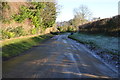
Village Street, Stoke Rochford
Looking down the hill towards the church.
Image: © Julian P Guffogg
Taken: 29 Dec 2016
0.07 miles
3
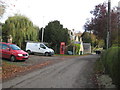
An Autumn walk
Ramblers enjoy a stroll through the picturesque village of Stoke Rochford.
Image: © Anthony Vosper
Taken: 5 Nov 2016
0.07 miles
4
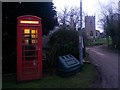
Stoke Rochford: the telephone box
It is just dark enough that the light has come on in the box. The church, in the next gridsquare east, is in the background.
Image: © Chris Downer
Taken: 3 Feb 2017
0.08 miles
5
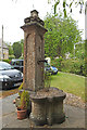
Elaborate village pump at Stoke Rochford
Water pump. Grade II listed; Mid C19. Ashlar. Square base with shaped rounded
basin, tapering panelled sides with moulded cornice and base only
of lost finial. In the front panel a bronze spigot and to the
rear an iron handle. Information from https://britishlistedbuildings.co.uk/101062296
Image: © Adrian S Pye
Taken: 8 Jun 2020
0.08 miles
6
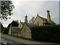
Stoke Rochford, Lincolnshire
An estate-built village attached to Stoke Rochford Hall.
Image: © Kate Jewell
Taken: 23 Oct 2005
0.09 miles
7
The Old School and School House, Stoke Rochford
Designed by William Burn 1840 https://historicengland.org.uk/listing/the-list/list-entry/1306993
Image: © Jonathan Thacker
Taken: 11 Oct 2020
0.09 miles
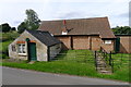
8

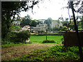
The upper part of the lake, Stoke Rochford Park
The course of the Cringle Brook can be ientified by the discoloured water following recent heavy rain.
Image: © Jonathan Thacker
Taken: 11 Oct 2020
0.10 miles
9

Cottage, School Close, Stoke Rochford
Designed by William Burn c1840 https://historicengland.org.uk/listing/the-list/list-entry/1360352
Image: © Jonathan Thacker
Taken: 11 Oct 2020
0.11 miles
10
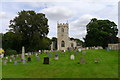
Church of St Andrew and St Mary, North and South Stoke with Easton
The village of North Stoke (with a church dedicated to St Andrew) was subsumed by the Stoke Rochford estate, and its dedication transferred to the church at South Stoke (dedicated to St Mary). The village of South Stoke was renamed Stoke Rochford. [Wikipedia]
Image: © Tim Heaton
Taken: 20 Aug 2017
0.11 miles