IMAGES TAKEN NEAR TO
Stroxton, GRANTHAM, NG33 5DA
Introduction
This page details the photographs taken nearby to NG33 5DA by members of the Geograph project.
The Geograph project started in 2005 with the aim of publishing, organising and preserving representative images for every square kilometre of Great Britain, Ireland and the Isle of Man.

There are currently over 7.5m images from over14,400 individuals and you can help contribute to the project by visiting https://www.geograph.org.uk
Image Map
Images are licensed for reuse under creativecommons.org/licenses/by-sa/2.0
Notes
- Clicking on the map will re-center to the selected point.
- The higher the marker number, the further away the image location is from the centre of the postcode.
Image Listing (31 Images Found)
Images are licensed for reuse under creativecommons.org/licenses/by-sa/2.0
Image
Details
Distance
2
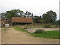
The back of Church Farm
Some of the traditional farmyard buildings have been converted into dwellings, and the farmyard itself superseded by modern buildings close at hand http://www.geograph.org.uk/photo/3601494 .
Image: © Alan Murray-Rust
Taken: 11 Aug 2013
0.03 miles
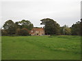
3
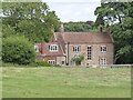
Church Farm House
Seen from the churchyard.
Image: © Alan Murray-Rust
Taken: 11 Aug 2013
0.04 miles
4
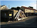
Farm building conversions
During the summer of 2005 the conversion of farm buildings at Church Farm in Stroxton advanced with speed.
Image: © Kate Jewell
Taken: 16 Aug 2005
0.04 miles
5
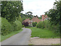
The approach to Stroxton village
Although in traditional materials, the houses on the right are of recent date.
Image: © Alan Murray-Rust
Taken: 11 Aug 2013
0.05 miles
6
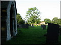
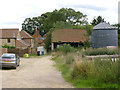
Church Farm from Stroxton church
All Saints Church lies at the end of a rough farm track through the Church Farm fields.
Part of the Harlaxton group of churches, Stroxton Church opens each year on Easter Sunday and has a service on the 1st Sunday of each month between easter Sunday and Harvest festival with a carol Service each Christmas.
Note that Stroxton is pronounced "Stroson"
Image: © Kate Jewell
Taken: 16 Aug 2005
0.06 miles
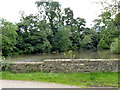
8
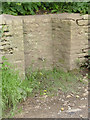
Tap in the wall
Alongside the road through Stroxton. This would presumably have been the original supply of drinking water for the village.
Image: © Alan Murray-Rust
Taken: 11 Aug 2013
0.06 miles
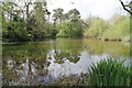
10
Stroxton pond
The road through the village acts as a dam to form the pond, but although it looks as if there could have been a mill here, the stream would not have been sufficiently large. The pond is labelled as a fish pond on early OS maps.
Image: © Alan Murray-Rust
Taken: 11 Aug 2013
0.08 miles